
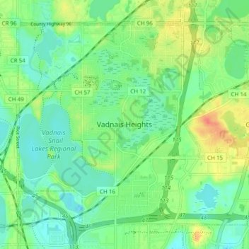
Vadnais Heights topographic map
Interactive map
Click on the map to display elevation.
About this map
Name: Vadnais Heights topographic map, elevation, terrain.
Average elevation: 915 ft
Minimum elevation: 863 ft
Maximum elevation: 1,014 ft
Ramsey County trails, hiking, mountain biking, running and outdoor activities
Other topographic maps
Click on a map to view its topography, its elevation and its terrain.
Saint Paul
United States > Minnesota > Ramsey County > Saint Paul
The year 1858 saw more than 1,000 steamboats service Saint Paul, making it a gateway for settlers to the Minnesota frontier or Dakota Territory. Geography was a primary reason the city became a transportation hub. The location was the last good point to land riverboats coming upriver due to the river valley's…
Average elevation: 896 ft
Gervais Lake Beach
United States > Minnesota > Ramsey County > Little Canada
Average elevation: 896 ft