
Marlborough topographic map
Interactive map
Click on the map to display elevation.
About this map
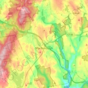
Name: Marlborough topographic map, elevation, terrain.
Average elevation: 509 ft
Minimum elevation: 157 ft
Maximum elevation: 899 ft
Capitol Planning Region trails, hiking, mountain biking, running and outdoor activities
Other topographic maps
Click on a map to view its topography, its elevation and its terrain.
Griswoldville
United States > Connecticut > Capitol Planning Region > Wethersfield
Average elevation: 112 ft
Spoonville
United States > Connecticut > Capitol Planning Region > East Granby
Average elevation: 203 ft
Cottage Grove
United States > Connecticut > Capitol Planning Region > Bloomfield
Average elevation: 102 ft
Unionville
United States > Connecticut > Capitol Planning Region > Farmington
Average elevation: 315 ft
Four Corners
United States > Connecticut > Capitol Planning Region > Terramuggus
Average elevation: 469 ft
Johnson Hill
United States > Connecticut > Capitol Planning Region > West Hartford
Average elevation: 112 ft
Talcott Mountain
United States > Connecticut > Capitol Planning Region > Bloomfield
Average elevation: 499 ft
Unionville
United States > Connecticut > Capitol Planning Region > Farmington
Average elevation: 315 ft
Stafford Springs
United States > Connecticut > Capitol Planning Region > Stafford
Average elevation: 656 ft
Barbara Drive
United States > Connecticut > Capitol Planning Region > Windsor Locks
Average elevation: 128 ft
Thompsonville
United States > Connecticut > Capitol Planning Region > Enfield
Average elevation: 105 ft
Fernridge Place
United States > Connecticut > Capitol Planning Region > West Hartford
Average elevation: 131 ft
Whitings Corner
United States > Connecticut > Capitol Planning Region > West Hartford
Average elevation: 276 ft
Buckingham
United States > Connecticut > Capitol Planning Region > Glastonbury
Average elevation: 430 ft