
Sterling topographic map
Interactive map
Click on the map to display elevation.
About this map
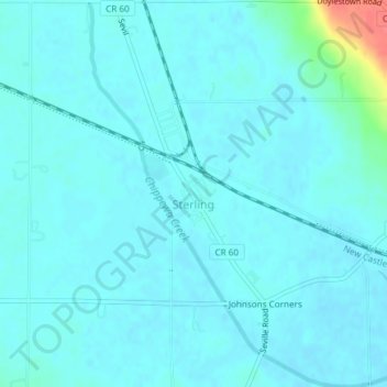
Name: Sterling topographic map, elevation, terrain.
Location: Sterling, Wayne County, Ohio, United States of America (40.95425 -81.85853 40.98239 -81.83096)
Average elevation: 974 ft
Minimum elevation: 951 ft
Maximum elevation: 1,148 ft
Other topographic maps
Click on a map to view its topography, its elevation and its terrain.
Mount Airy Forest
United States of America > Ohio > Cincinnati > Mount Airy Center
Average elevation: 755 ft
William Howard Taft National Historic Site
United States of America > Ohio > Cincinnati
Average elevation: 722 ft
Pleasant Heights
United States of America > Ohio > East Liverpool > Pleasant Heights
Average elevation: 984 ft
Reynolds Corners
United States of America > Ohio > Toledo > Reynolds Corners
Average elevation: 630 ft
Johnston Corners
United States of America > Ohio > Toledo > Johnston Corners
Average elevation: 627 ft
Perkins Corners
United States of America > Ohio > Youngstown > Perkins Corners
Average elevation: 1,037 ft