
Latrobe topographic map
Interactive map
Click on the map to display elevation.
About this map
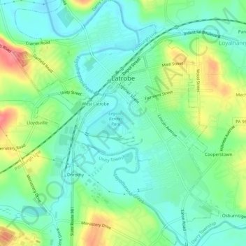
Name: Latrobe topographic map, elevation, terrain.
Location: Latrobe, Westmoreland County, Pennsylvania, United States (40.29214 -79.40385 40.32889 -79.36524)
Average elevation: 1,040 ft
Minimum elevation: 955 ft
Maximum elevation: 1,214 ft
Westmoreland County trails, hiking, mountain biking, running and outdoor activities
Other topographic maps
Click on a map to view its topography, its elevation and its terrain.
Twin Lakes Park
United States > Pennsylvania > Westmoreland County > Hempfield Township > Luxor > Georges Station
Average elevation: 1,204 ft
Circleville
United States > Pennsylvania > Westmoreland County > North Huntingdon Township
Average elevation: 1,093 ft
Alverton
United States > Pennsylvania > Westmoreland County > East Huntingdon Township
Average elevation: 1,184 ft
Millwood
United States > Pennsylvania > Westmoreland County > Derry Township
Average elevation: 1,335 ft
Buckeye
United States > Pennsylvania > Westmoreland County > East Huntingdon Township
Average elevation: 1,109 ft
Tarrs
United States > Pennsylvania > Westmoreland County > East Huntingdon Township
Average elevation: 1,168 ft
Collinsburg
United States > Pennsylvania > Westmoreland County > Rostraver Township
Average elevation: 925 ft
Painter Rock Hill
United States > Pennsylvania > Westmoreland County > Donegal Township
Average elevation: 2,562 ft
Yukon
United States > Pennsylvania > Westmoreland County > South Huntingdon Township
Average elevation: 1,033 ft
Keystone State Park
United States > Pennsylvania > Westmoreland County > Derry Township
Average elevation: 1,155 ft
Superior
United States > Pennsylvania > Westmoreland County > Derry Township
Average elevation: 1,168 ft
Southwest
United States > Pennsylvania > Westmoreland County > Mount Pleasant Township
Average elevation: 1,102 ft
Camp Jo-Ann
United States > Pennsylvania > Westmoreland County > Murrysville > Camp Jo-Ann
Average elevation: 1,125 ft
Bessemer
United States > Pennsylvania > Westmoreland County > East Huntingdon Township > Bessemer
Average elevation: 1,122 ft
Bessemer
United States > Pennsylvania > Westmoreland County > East Huntingdon Township
Average elevation: 1,122 ft
Maplewood Terrace
United States > Pennsylvania > Westmoreland County > Hempfield Township > Maplewood Terrace
Average elevation: 1,135 ft