
Bergenfield topographic map
Interactive map
Click on the map to display elevation.
About this map
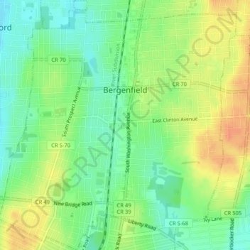
Name: Bergenfield topographic map, elevation, terrain.
Location: Bergenfield, Bergen County, New Jersey, 07621, United States (40.90839 -74.01746 40.93829 -73.97971)
Average elevation: 98 ft
Minimum elevation: 36 ft
Maximum elevation: 167 ft
Bergen County trails, hiking, mountain biking, running and outdoor activities
Other topographic maps
Click on a map to view its topography, its elevation and its terrain.
Hillsdale
United States > New Jersey > Bergen County > Hillsdale > Hillsdale
Average elevation: 131 ft
Ridgefield Park
United States > New Jersey > Bergen County > Ridgefield Park > Ridgefield Park
Average elevation: 69 ft
Glen Rock
United States > New Jersey > Bergen County > Glen Rock > Glen Rock
Average elevation: 171 ft