
Groton topographic map
Interactive map
Click on the map to display elevation.
About this map
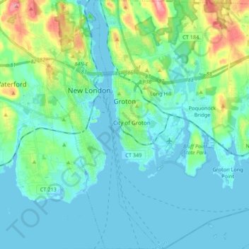
Name: Groton topographic map, elevation, terrain.
Average elevation: 69 ft
Minimum elevation: -13 ft
Maximum elevation: 364 ft
Other topographic maps
Click on a map to view its topography, its elevation and its terrain.
Mystic
United States > Connecticut > Southeastern Connecticut Planning Region
Average elevation: 79 ft
Oakdale
United States > Connecticut > Southeastern Connecticut Planning Region > Montville
Average elevation: 463 ft
Taftville Reservoir #1 Dam
United States > Connecticut > Southeastern Connecticut Planning Region > Norwich
Average elevation: 246 ft
Quiambaug
United States > Connecticut > Southeastern Connecticut Planning Region > Mystic
Average elevation: 26 ft
Four Corners
United States > Connecticut > Southeastern Connecticut Planning Region > Montville
Average elevation: 354 ft
Manitock Spring
United States > Connecticut > Southeastern Connecticut Planning Region > Waterford
Average elevation: 85 ft
Flanders
United States > Connecticut > Southeastern Connecticut Planning Region > East Lyme
Average elevation: 141 ft
Chesterfield
United States > Connecticut > Southeastern Connecticut Planning Region > Montville
Average elevation: 253 ft
High Rock
United States > Connecticut > Southeastern Connecticut Planning Region > Waterford
Average elevation: 128 ft
Flanders
United States > Connecticut > Southeastern Connecticut Planning Region > East Lyme
Average elevation: 141 ft
Austrailia Beach
United States > Connecticut > Southeastern Connecticut Planning Region > Stonington > Mystic
Average elevation: 62 ft
Chesterfield
United States > Connecticut > Southeastern Connecticut Planning Region > Montville
Average elevation: 253 ft
Uncasville
United States > Connecticut > Southeastern Connecticut Planning Region > Montville
Average elevation: 131 ft
Center Groton
United States > Connecticut > Southeastern Connecticut Planning Region > Groton
Average elevation: 161 ft
Quaker Hill
United States > Connecticut > Southeastern Connecticut Planning Region > Waterford
Average elevation: 115 ft
North Stonington
United States > Connecticut > Southeastern Connecticut Planning Region
Average elevation: 240 ft
Mystic
United States > Connecticut > Southeastern Connecticut Planning Region > Stonington
Average elevation: 56 ft
Avery Hill
United States > Connecticut > Southeastern Connecticut Planning Region > Ledyard
Average elevation: 171 ft
North Franklin
United States > Connecticut > Southeastern Connecticut Planning Region
Average elevation: 338 ft
Seal Rocks
United States > Connecticut > Southeastern Connecticut Planning Region > Stonington
Average elevation: 121 ft