
Make a donation
Gear up for your next adventure:
As an Amazon Associate, this site earns from qualifying purchases at no extra cost to you.
Mystic topographic map
Click on the map to display elevation.
Make a donation
Gear up for your next adventure:
As an Amazon Associate, this site earns from qualifying purchases at no extra cost to you.
About this map
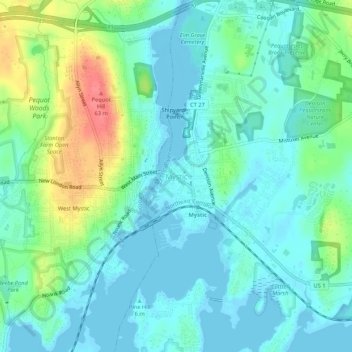
Name: Mystic topographic map, elevation, terrain.
Average elevation: 79 ft
Minimum elevation: -7 ft
Maximum elevation: 312 ft
Make a donation
Gear up for your next adventure:
As an Amazon Associate, this site earns from qualifying purchases at no extra cost to you.
Other topographic maps
Click on a map to view its topography, its elevation and its terrain.
Ledyard
United States > Connecticut > Southeastern Connecticut Planning Region
Average elevation: 174 ft
Mystic
United States > Connecticut > Southeastern Connecticut Planning Region > Stonington > Mystic
Average elevation: 49 ft
Groton
United States > Connecticut > Southeastern Connecticut Planning Region
Average elevation: 69 ft
Norwich
United States > Connecticut > Southeastern Connecticut Planning Region
Average elevation: 207 ft
Make a donation
Gear up for your next adventure:
As an Amazon Associate, this site earns from qualifying purchases at no extra cost to you.
East Lyme
United States > Connecticut > Southeastern Connecticut Planning Region
The topography of East Lyme consists of rolling hills and lush valleys rounded by glaciers during the last Ice Age. Hills rise to elevations of 250 to 350 feet (76 to 107 m) above sea level in the eastern and central areas of the town. The highest point in town is an unnamed hill with an elevation of 500 feet…
Average elevation: 135 ft
New London
United States > Connecticut > Southeastern Connecticut Planning Region
Average elevation: 56 ft
Franklin
United States > Connecticut > Southeastern Connecticut Planning Region
Average elevation: 312 ft
Mystic
United States > Connecticut > Southeastern Connecticut Planning Region > Stonington > Mystic
Average elevation: 49 ft
Make a donation
Gear up for your next adventure:
As an Amazon Associate, this site earns from qualifying purchases at no extra cost to you.
Waterford
United States > Connecticut > Southeastern Connecticut Planning Region
Average elevation: 98 ft
Bozrah
United States > Connecticut > Southeastern Connecticut Planning Region
Average elevation: 318 ft
Salem
United States > Connecticut > Southeastern Connecticut Planning Region
Average elevation: 390 ft
Gales Ferry
United States > Connecticut > Southeastern Connecticut Planning Region > Ledyard > Gales Ferry
Average elevation: 79 ft
Make a donation
Gear up for your next adventure:
As an Amazon Associate, this site earns from qualifying purchases at no extra cost to you.
Colchester
United States > Connecticut > Southeastern Connecticut Planning Region
Average elevation: 440 ft
Lebanon
United States > Connecticut > Southeastern Connecticut Planning Region
Average elevation: 390 ft
Taftville
United States > Connecticut > Southeastern Connecticut Planning Region > Norwich
Average elevation: 154 ft
Austrailia Beach
United States > Connecticut > Southeastern Connecticut Planning Region > Mystic
Average elevation: 62 ft
Make a donation
Gear up for your next adventure:
As an Amazon Associate, this site earns from qualifying purchases at no extra cost to you.
Old Mystic
United States > Connecticut > Southeastern Connecticut Planning Region > Groton > Old Mystic
Average elevation: 138 ft
Windham
United States > Connecticut > Southeastern Connecticut Planning Region
Average elevation: 338 ft
Austrailia Beach
United States > Connecticut > Southeastern Connecticut Planning Region > Mystic
Average elevation: 62 ft
Franklin
United States > Connecticut > Southeastern Connecticut Planning Region
Average elevation: 312 ft
Make a donation
Gear up for your next adventure:
As an Amazon Associate, this site earns from qualifying purchases at no extra cost to you.
North Stonington
United States > Connecticut > Southeastern Connecticut Planning Region
Average elevation: 256 ft
Noank
United States > Connecticut > Southeastern Connecticut Planning Region > Groton > Noank
Average elevation: 49 ft
Stonington
United States > Connecticut > Southeastern Connecticut Planning Region
Average elevation: 82 ft
Windham
United States > Connecticut > Southeastern Connecticut Planning Region
Average elevation: 338 ft
Make a donation
Gear up for your next adventure:
As an Amazon Associate, this site earns from qualifying purchases at no extra cost to you.
Ledyard
United States > Connecticut > Southeastern Connecticut Planning Region
Average elevation: 174 ft
Montville
United States > Connecticut > Southeastern Connecticut Planning Region
Average elevation: 262 ft
Taftville Reservoir #1 Dam
United States > Connecticut > Southeastern Connecticut Planning Region > Norwich
Average elevation: 246 ft
Montville
United States > Connecticut > Southeastern Connecticut Planning Region
Average elevation: 249 ft
Make a donation
Gear up for your next adventure:
As an Amazon Associate, this site earns from qualifying purchases at no extra cost to you.
Sprague
United States > Connecticut > Southeastern Connecticut Planning Region
Average elevation: 259 ft
Blue Lake
United States > Connecticut > Southeastern Connecticut Planning Region > North Stonington
Average elevation: 348 ft
Thames River
United States > Connecticut > Southeastern Connecticut Planning Region > Waterford
Average elevation: 171 ft
New London
United States > Connecticut > Southeastern Connecticut Planning Region
Average elevation: 56 ft
Make a donation
Gear up for your next adventure:
As an Amazon Associate, this site earns from qualifying purchases at no extra cost to you.
Salem
United States > Connecticut > Southeastern Connecticut Planning Region
Average elevation: 390 ft
East Lyme
United States > Connecticut > Southeastern Connecticut Planning Region
The topography of East Lyme consists of rolling hills and lush valleys rounded by glaciers during the last Ice Age. Hills rise to elevations of 250 to 350 feet (76 to 107 m) above sea level in the eastern and central areas of the town. The highest point in town is an unnamed hill with an elevation of 500 feet…
Average elevation: 135 ft
Austrailia Beach
United States > Connecticut > Southeastern Connecticut Planning Region > Mystic
Average elevation: 62 ft
Stonington
United States > Connecticut > Southeastern Connecticut Planning Region
Average elevation: 82 ft
Make a donation
Gear up for your next adventure:
As an Amazon Associate, this site earns from qualifying purchases at no extra cost to you.
Bozrah
United States > Connecticut > Southeastern Connecticut Planning Region
Average elevation: 318 ft
Norwich
United States > Connecticut > Southeastern Connecticut Planning Region
Average elevation: 207 ft
New London
United States > Connecticut > Southeastern Connecticut Planning Region
Average elevation: 56 ft
Austrailia Beach
United States > Connecticut > Southeastern Connecticut Planning Region > Mystic
Average elevation: 62 ft
Make a donation
Gear up for your next adventure:
As an Amazon Associate, this site earns from qualifying purchases at no extra cost to you.
Hanover Reservoir
United States > Connecticut > Southeastern Connecticut Planning Region > Hanover
Average elevation: 299 ft
Preston
United States > Connecticut > Southeastern Connecticut Planning Region
Average elevation: 217 ft
Willimantic
United States > Connecticut > Southeastern Connecticut Planning Region > Willimantic > Windham
Average elevation: 312 ft
Groton
United States > Connecticut > Southeastern Connecticut Planning Region
Average elevation: 62 ft
Make a donation
Gear up for your next adventure:
As an Amazon Associate, this site earns from qualifying purchases at no extra cost to you.
North Stonington
United States > Connecticut > Southeastern Connecticut Planning Region
Average elevation: 240 ft
Lisbon
United States > Connecticut > Southeastern Connecticut Planning Region
Average elevation: 210 ft
Thames River
United States > Connecticut > Southeastern Connecticut Planning Region > Ledyard
Average elevation: 171 ft
Lebanon
United States > Connecticut > Southeastern Connecticut Planning Region
Average elevation: 390 ft
Make a donation
Gear up for your next adventure:
As an Amazon Associate, this site earns from qualifying purchases at no extra cost to you.
Waterford
United States > Connecticut > Southeastern Connecticut Planning Region
Average elevation: 98 ft
Harkness Memorial State Park
United States > Connecticut > Southeastern Connecticut Planning Region > Waterford
Average elevation: 39 ft
Stonington
United States > Connecticut > Southeastern Connecticut Planning Region
Average elevation: 82 ft
Norwich
United States > Connecticut > Southeastern Connecticut Planning Region
Average elevation: 207 ft
Make a donation
Gear up for your next adventure:
As an Amazon Associate, this site earns from qualifying purchases at no extra cost to you.
Groton
United States > Connecticut > Southeastern Connecticut Planning Region
Average elevation: 69 ft