
Livingston topographic map
Interactive map
Click on the map to display elevation.
Livingston
Elevation: 148 ft
About this map
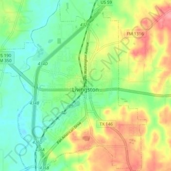
Name: Livingston topographic map, elevation, terrain.
Location: Livingston, Polk County, Texas, United States (30.68262 -94.97029 30.74201 -94.90823)
Average elevation: 207 ft
Minimum elevation: 92 ft
Maximum elevation: 381 ft
Polk County trails, hiking, mountain biking, running and outdoor activities
Other topographic maps
Click on a map to view its topography, its elevation and its terrain.