
Franklin County topographic map
Interactive map
Click on the map to display elevation.
Franklin County
According to the U.S. Census Bureau, the county has a total area of 1,743 square miles (4,510 km2), of which 1,697 square miles (4,400 km2) is land and 47 square miles (120 km2) (2.7%) is water. The county high point is Sugarloaf Mountain, the ski mountain in Carrabassett Valley whose elevation is 4237 feet.
About this map
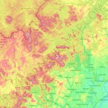
Name: Franklin County topographic map, elevation, terrain.
Location: Franklin County, Maine, United States (44.45895 -70.83571 45.66791 -69.92817)
Average elevation: 1,404 ft
Minimum elevation: 30 ft
Maximum elevation: 4,167 ft
Maine trails, hiking, mountain biking, running and outdoor activities
Other topographic maps
Click on a map to view its topography, its elevation and its terrain.
Cliff Island
United States > Maine > Cumberland County > Portland > Cliff Island
Average elevation: 3 ft
Saint John River
United States > Maine > Aroostook County > Saint John Plantation
The eastern Algonquin languages had different dialects associated with each of the major river systems of New England and the Maritimes; and there was often a linguistic bifurcation between residents of the upper river and those living along the coast and tidal estuary. The Passamaquoddy hunted sea mammals…
Average elevation: 650 ft
Cadillac Mountain
United States > Maine > Hancock County > Bar Harbor
Cadillac Mountain is located on Mount Desert Island, within Acadia National Park, in the U.S. state of Maine. With an elevation of 1,530 feet (470 meters), its summit is the highest point in Hancock County and the highest within 25 miles (40 km) of the Atlantic shoreline of the North American continent between…
Average elevation: 764 ft
Rockwood
United States > Maine > Somerset County > Rockwood Strip T1 R1 NBKP
Average elevation: 1,086 ft
Mount Katahdin
United States > Maine > Piscataquis County > Mount Katahdin Township
It is commonly thought that Katahdin is the first place in the United States mainland to receive sunlight in the morning, but this is incorrect. Other mountains lower in elevation but farther to the east or southeast see the first sunrise of the day, depending on the season. Regardless, the summit of Katahdin…
Average elevation: 3,990 ft
Mount Abraham
United States > Maine > Franklin County > Mount Abram Township
Average elevation: 3,012 ft
Caribou Mountain
United States > Maine > Franklin County > Skinner Township
Average elevation: 2,835 ft
East Livermore
United States > Maine > Androscoggin County > Livermore Falls
Average elevation: 364 ft