
Elberton topographic map
Interactive map
Click on the map to display elevation.
About this map
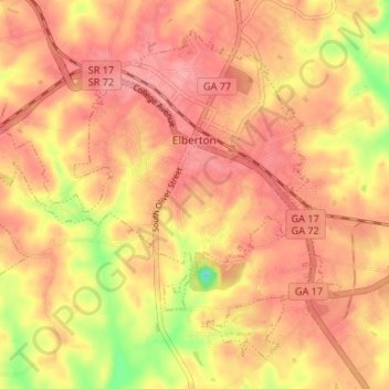
Name: Elberton topographic map, elevation, terrain.
Location: Elberton, Elbert County, Georgia, United States (34.08020 -82.90852 34.12669 -82.84217)
Average elevation: 636 ft
Minimum elevation: 427 ft
Maximum elevation: 728 ft
Elbert County trails, hiking, mountain biking, running and outdoor activities
Other topographic maps
Click on a map to view its topography, its elevation and its terrain.