
Pennsburg topographic map
Interactive map
Click on the map to display elevation.
Pennsburg
Pennsburg is located at 40°23′44″N 75°29′50″W / 40.39556°N 75.49722°W / 40.39556; -75.49722 (40.395595, −75.497361). According to the United States Census Bureau, the borough has a total area of 0.8 square miles (2.1 km2), all land. Pennsburg is located 40 mi (64 km) northwest of Philadelphia and 5 mi (8.0 km) southwest of Quakertown. Pennsburg's elevation is at 350 ft (110 m) above sea level. A nature preserve is along Macoby Creek.
About this map
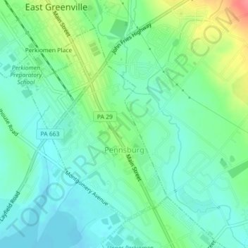
Name: Pennsburg topographic map, elevation, terrain.
Location: Pennsburg, Montgomery County, Pennsylvania, United States (40.38326 -75.50767 40.40418 -75.48599)
Average elevation: 351 ft
Minimum elevation: 279 ft
Maximum elevation: 525 ft
Montgomery County trails, hiking, mountain biking, running and outdoor activities
Other topographic maps
Click on a map to view its topography, its elevation and its terrain.
Eagleville
United States > Pennsylvania > Montgomery County > Lower Providence Township
Average elevation: 335 ft
Shirks Corner
United States > Pennsylvania > Montgomery County > Upper Salford Township
Average elevation: 262 ft
Perkiomen Place
United States > Pennsylvania > Montgomery County > East Greenville
Average elevation: 367 ft
Zieglersville
United States > Pennsylvania > Montgomery County > Lower Frederick
Average elevation: 272 ft
Fulmor
United States > Pennsylvania > Montgomery County > Upper Moreland Township
Average elevation: 259 ft
Morganville
United States > Pennsylvania > Montgomery County > Upper Moreland Township > Willow Grove
Average elevation: 266 ft
Willow Grove
United States > Pennsylvania > Montgomery County > Upper Moreland Township
Average elevation: 299 ft
Maple Glen
United States > Pennsylvania > Montgomery County > Upper Dublin Township
Average elevation: 335 ft
Worcester
United States > Pennsylvania > Montgomery County > Worcester Township
Average elevation: 305 ft
Rydal Park
United States > Pennsylvania > Montgomery County > Abington Township
Average elevation: 285 ft
Lafayette Park
United States > Pennsylvania > Montgomery County > Upper Merion Township > King of Prussia
Average elevation: 177 ft
Hidden Valley
United States > Pennsylvania > Montgomery County > Upper Merion Township > King of Prussia
Average elevation: 154 ft
Springtown
United States > Pennsylvania > Montgomery County > East Norriton Township
Average elevation: 243 ft
Three Tuns
United States > Pennsylvania > Montgomery County > Upper Dublin Township
Average elevation: 331 ft
Bob White Farms
United States > Pennsylvania > Montgomery County > Upper Merion Township
Average elevation: 312 ft
Orvilla
United States > Pennsylvania > Montgomery County > Hatfield Township
Average elevation: 328 ft
Enfield
United States > Pennsylvania > Montgomery County > Springfield Township
Average elevation: 285 ft
Wyncote
United States > Pennsylvania > Montgomery County > Cheltenham Township
Average elevation: 302 ft
Mount Vernon Gardens
United States > Pennsylvania > Montgomery County > Abington Township
Average elevation: 305 ft
Fairoaks
United States > Pennsylvania > Montgomery County > Horsham Township > Horsham
Average elevation: 276 ft
Cynwyd Estates
United States > Pennsylvania > Montgomery County > Lower Merion Township
Average elevation: 262 ft
Perkiomenville
United States > Pennsylvania > Montgomery County > Marlborough Township
Average elevation: 318 ft
Wynmere Downs
United States > Pennsylvania > Montgomery County > Horsham Township
Average elevation: 322 ft
Mount Pleasant
United States > Pennsylvania > Montgomery County > Whitpain Township
Average elevation: 256 ft
Meadowbrook
United States > Pennsylvania > Montgomery County > Abington Township
Average elevation: 217 ft
Harleysville
United States > Pennsylvania > Montgomery County > Lower Salford Township
Average elevation: 299 ft
Prospectville
United States > Pennsylvania > Montgomery County > Horsham Township
Average elevation: 312 ft
Elkins Park Gardens
United States > Pennsylvania > Montgomery County > Cheltenham Township > Cheltenham
Average elevation: 230 ft
Gilbertsville
United States > Pennsylvania > Montgomery County > Douglass Township
Average elevation: 318 ft
Belmont Hills
United States > Pennsylvania > Montgomery County > Lower Merion Township
Average elevation: 236 ft
Meng Preserve
United States > Pennsylvania > Montgomery County > Schwenksville
Average elevation: 308 ft
Hollywood
United States > Pennsylvania > Montgomery County > Abington Township
Average elevation: 226 ft
Franconia
United States > Pennsylvania > Montgomery County > Franconia Township
Average elevation: 351 ft
Glenside
United States > Pennsylvania > Montgomery County > Abington Township
Average elevation: 308 ft
Bryn Mawr
United States > Pennsylvania > Montgomery County > Lower Merion Township > Bryn Mawr
Average elevation: 358 ft
Gladwyne Park
United States > Pennsylvania > Montgomery County > Lower Merion Township > Gladwyne
Average elevation: 315 ft
Flourtown
United States > Pennsylvania > Montgomery County > Springfield Township
Average elevation: 213 ft
Penn Valley
United States > Pennsylvania > Montgomery County > Lower Merion Township > Penn Valley
Average elevation: 292 ft
Palm
United States > Pennsylvania > Montgomery County > Upper Hanover Township > Palm
Average elevation: 430 ft
Ardmore
United States > Pennsylvania > Montgomery County > Lower Merion Township
Average elevation: 322 ft
Evansburg
United States > Pennsylvania > Montgomery County > Lower Providence Township
Average elevation: 210 ft
Montgomeryville
United States > Pennsylvania > Montgomery County > Montgomery Township
Average elevation: 404 ft
Spring Mountain
United States > Pennsylvania > Montgomery County > Upper Salford Township
Average elevation: 236 ft
Oak Summit
United States > Pennsylvania > Montgomery County > Cheltenham Township > Oak Summit
Average elevation: 318 ft
Oreland
United States > Pennsylvania > Montgomery County > Upper Dublin Township
Average elevation: 262 ft
Ridge Estates
United States > Pennsylvania > Montgomery County > Lower Pottsgrove Township > Ridge Estates
Average elevation: 302 ft
Sanatoga
United States > Pennsylvania > Montgomery County > Lower Pottsgrove Township
Average elevation: 226 ft
Conshohocken Station
United States > Pennsylvania > Montgomery County > Upper Merion Township
Average elevation: 322 ft
Harley Corners
United States > Pennsylvania > Montgomery County > East Norriton Township > Harley Corners
Average elevation: 344 ft
Cannon Run
United States > Pennsylvania > Montgomery County > King of Prussia > Cannon Run
Average elevation: 187 ft
Ardsley
United States > Pennsylvania > Montgomery County > Abington Township > Ardsley
Average elevation: 292 ft