
Kendrick topographic map
Interactive map
Click on the map to display elevation.
About this map
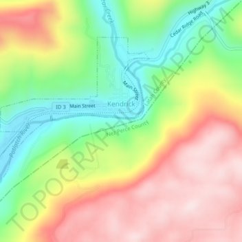
Name: Kendrick topographic map, elevation, terrain.
Location: Kendrick, Latah County, Idaho, 83537, United States (46.60276 -116.67323 46.62148 -116.64198)
Average elevation: 1,834 ft
Minimum elevation: 1,161 ft
Maximum elevation: 2,536 ft
Latah County trails, hiking, mountain biking, running and outdoor activities
Other topographic maps
Click on a map to view its topography, its elevation and its terrain.