
Onalaska topographic map
Interactive map
Click on the map to display elevation.
About this map
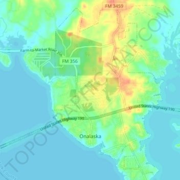
Name: Onalaska topographic map, elevation, terrain.
Location: Onalaska, Polk County, Texas, 77360, United States (30.79285 -95.15635 30.84829 -95.08862)
Average elevation: 161 ft
Minimum elevation: 128 ft
Maximum elevation: 253 ft
Polk County trails, hiking, mountain biking, running and outdoor activities
Other topographic maps
Click on a map to view its topography, its elevation and its terrain.