
Louisa topographic map
Interactive map
Click on the map to display elevation.
About this map
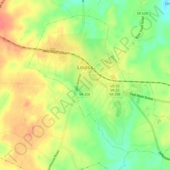
Name: Louisa topographic map, elevation, terrain.
Location: Louisa, Louisa County, Virginia, United States (38.00787 -78.01780 38.03520 -77.97569)
Average elevation: 436 ft
Minimum elevation: 331 ft
Maximum elevation: 525 ft
Louisa County trails, hiking, mountain biking, running and outdoor activities
Other topographic maps
Click on a map to view its topography, its elevation and its terrain.