
City of Port Jervis topographic map
Interactive map
Click on the map to display elevation.
About this map
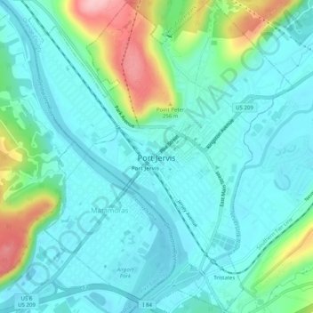
Name: City of Port Jervis topographic map, elevation, terrain.
Location: City of Port Jervis, Orange County, New York, United States (41.35667 -74.71315 41.39411 -74.67085)
Average elevation: 528 ft
Minimum elevation: 394 ft
Maximum elevation: 997 ft
Orange County trails, hiking, mountain biking, running and outdoor activities
Other topographic maps
Click on a map to view its topography, its elevation and its terrain.
Cornwall Landing
United States > New York > Orange County > Village of Cornwall-on-Hudson
Average elevation: 243 ft
Highland Mills
United States > New York > Orange County > Village of Woodbury
Average elevation: 682 ft
Central Valley
United States > New York > Orange County > Village of Woodbury
Average elevation: 673 ft