
Lexington topographic map
Interactive map
Click on the map to display elevation.
About this map
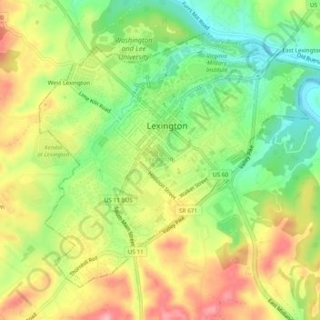
Name: Lexington topographic map, elevation, terrain.
Location: Lexington, Virginia, United States of America (37.76513 -79.46192 37.79484 -79.41495)
Average elevation: 1,086 ft
Minimum elevation: 889 ft
Maximum elevation: 1,302 ft
Other topographic maps
Click on a map to view its topography, its elevation and its terrain.
Michaelwood
United States of America > Virginia > Virginia Beach > Michaelwood
Average elevation: 16 ft
Charlestown Lakes South
United States of America > Virginia > Charlestown Lakes South
Average elevation: 26 ft
Inland Colony
United States of America > Virginia > Chesapeake > Inland Colony
Average elevation: 10 ft
Broyhill-Glen Gary Park
United States of America > Virginia > Broyhill-Glen Gary Park
Average elevation: 299 ft
Mount Pleasant
United States of America > Virginia > Chesapeake > Mount Pleasant
Average elevation: 13 ft
Penn Laird
United States of America > Virginia > Harrisonburg > Penn Laird
Average elevation: 1,365 ft
Mulberry Greens
United States of America > Virginia > Culpeper > Mulberry Greens
Average elevation: 443 ft