
Refúgio de Vida Silvestre dos Campos de Palmas topographic map
Interactive map
Click on the map to display elevation.
About this map
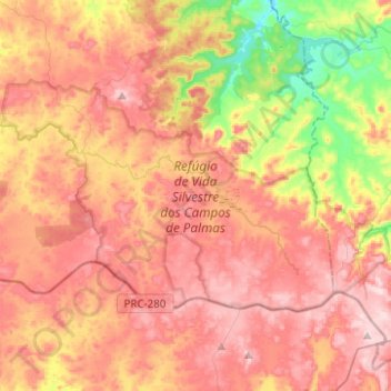
Name: Refúgio de Vida Silvestre dos Campos de Palmas topographic map, elevation, terrain.
Average elevation: 4,029 ft
Minimum elevation: 3,379 ft
Maximum elevation: 4,508 ft
Other topographic maps
Click on a map to view its topography, its elevation and its terrain.
União da Vitória
After that, European immigrants, such as Ukrainians, Poles, Germans and Italians settled with their families in the region, attracted mainly by the similar climate, topography, vegetation and opportunity of having a better quality of life.
Average elevation: 2,963 ft
Umuarama
Brazil > Paraná > Região Metropolitana de Umuarama
Umuarama is a municipality in the state of Paraná in Brazil. Its population was 112,500 inhabitants in 2020. Umuarama is one of the most important cities in Paraná, one of the three states of southern Brazil. The city elevation is 430 m (1,300 feet) above sea level and the rainfall is about 1600mm/year (63…
Average elevation: 1,237 ft
Colombo
Brazil > Paraná > Região Metropolitana de Curitiba
It was founded on 5 February 1890. It is located at 25º17'30" S, 49º13'27" W, at an elevation of about 1000 metres above sea level, some 18 km from state capital Curitiba. The city is the largest Italian colony in the state.
Average elevation: 3,189 ft
Rio Branco do Sul
Brazil > Paraná > Região Metropolitana de Curitiba > Rio Branco do Sul > Rio Branco do Sul
Average elevation: 3,169 ft