Geolocate

Morton topographic map

Interactive map

Click on the map to display elevation.

About this map

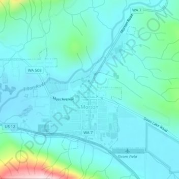
Name: Morton topographic map, elevation, terrain.

Location: Morton, Lewis County, Washington, United States (46.55011 -122.30137 46.56922 -122.26288)

Average elevation: 1,076 ft

Minimum elevation: 869 ft

Maximum elevation: 2,201 ft

Lewis County trails, hiking, mountain biking, running and outdoor activities

Other topographic maps

Click on a map to view its topography, its elevation and its terrain.

Pompey Peak

United States > Washington > Lewis County

Average elevation: 3,793 ft

Cinebar

United States > Washington > Lewis County

Average elevation: 1,010 ft

Narada Falls

United States > Washington > Lewis County

Average elevation: 4,738 ft

Walupt Creek Falls

United States > Washington > Lewis County

Average elevation: 3,799 ft

Bremer

United States > Washington > Lewis County

Average elevation: 1,411 ft

Packwood

United States > Washington > Lewis County

Average elevation: 1,243 ft

Adna

United States > Washington > Lewis County

Average elevation: 269 ft

Chimney Rock

United States > Washington > Lewis County

Average elevation: 5,226 ft

Vader

United States > Washington > Lewis County

Average elevation: 243 ft

Onalaska

United States > Washington > Lewis County

Average elevation: 558 ft

Glenoma

United States > Washington > Lewis County

Average elevation: 1,161 ft

Mineral

United States > Washington > Lewis County > Mineral

Average elevation: 1,578 ft