
Thank you for supporting this site ❤️
Make a donation
Make a donation
Gear up for your next adventure:
As an Amazon Associate, this site earns from qualifying purchases at no extra cost to you.
Missoula topographic map
Click on the map to display elevation.
Thank you for supporting this site ❤️
Make a donation
Make a donation
Gear up for your next adventure:
As an Amazon Associate, this site earns from qualifying purchases at no extra cost to you.
About this map
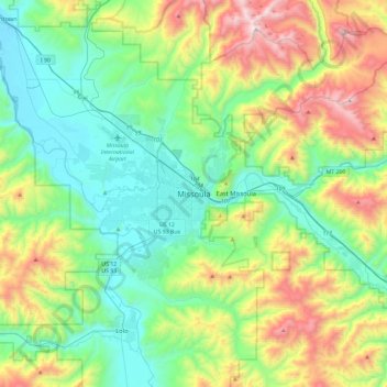
Name: Missoula topographic map, elevation, terrain.
Location: Missoula, Missoula County, Montana, 59807, United States (46.71010 -114.15527 47.03010 -113.83527)
Average elevation: 4,442 ft
Minimum elevation: 3,025 ft
Maximum elevation: 7,884 ft
Missoula County trails, hiking, mountain biking, running and outdoor activities
Thank you for supporting this site ❤️
Make a donation
Make a donation
Gear up for your next adventure:
As an Amazon Associate, this site earns from qualifying purchases at no extra cost to you.