
Make a donation
Gear up for your next adventure:
As an Amazon Associate, this site earns from qualifying purchases at no extra cost to you.
Smoky Mountain topographic map
Click on the map to display elevation.
Make a donation
Gear up for your next adventure:
As an Amazon Associate, this site earns from qualifying purchases at no extra cost to you.
About this map
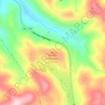
Name: Smoky Mountain topographic map, elevation, terrain.
Average elevation: 3,724 ft
Minimum elevation: 3,192 ft
Maximum elevation: 4,265 ft
Make a donation
Gear up for your next adventure:
As an Amazon Associate, this site earns from qualifying purchases at no extra cost to you.
Other topographic maps
Click on a map to view its topography, its elevation and its terrain.
Elizabeth City
United States of America > North Carolina > Elizabeth City
According to the United States Census Bureau, Elizabeth City has a total area of 12.2 square miles (31.7 km2), of which 11.6 square miles (30.1 km2) is land and 0.62 square miles (1.6 km2), or 5.09%, is water. Located in the "Inner Banks" region of North Carolina, Elizabeth City is largely flat and marshy with…
Average elevation: 13 ft