
Dallas topographic map
Interactive map
Click on the map to display elevation.
About this map
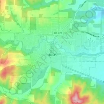
Name: Dallas topographic map, elevation, terrain.
Location: Dallas, Polk County, Oregon, 97338, United States (44.90314 -123.34915 44.93801 -123.27495)
Average elevation: 390 ft
Minimum elevation: 220 ft
Maximum elevation: 823 ft
Dallas is along Rickreall Creek, about 15 miles (24 km) west of Salem, at an elevation of 325 feet (99 m) above sea level. It is part of the Salem Metropolitan Statistical Area.
Other topographic maps
Click on a map to view its topography, its elevation and its terrain.
Willamette River
United States > Oregon > Polk County
Willamette River, Polk County, Oregon, United States
Average elevation: 236 ft
Monmouth
United States > Oregon > Polk County
Monmouth, Polk County, Oregon, United States
Average elevation: 190 ft
Buena Vista
United States > Oregon > Polk County
Buena Vista, Polk County, Oregon, United States
Average elevation: 220 ft
Aaron Mercer Reservoir
United States > Oregon > Polk County
Aaron Mercer Reservoir, Polk County, Oregon, United States
Average elevation: 1,204 ft
Independence
United States > Oregon > Polk County
Independence, Polk County, Oregon, 97351, United States
Average elevation: 164 ft
Grand Ronde
United States > Oregon > Polk County > Grand Ronde
Grand Ronde, Polk County, Oregon, United States
Average elevation: 433 ft