
Interlachen topographic map
Interactive map
Click on the map to display elevation.
About this map
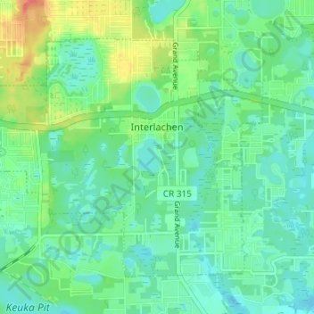
Name: Interlachen topographic map, elevation, terrain.
Location: Interlachen, Putnam County, Florida, United States (29.59861 -81.93071 29.63881 -81.86996)
Average elevation: 102 ft
Minimum elevation: 52 ft
Maximum elevation: 220 ft
Putnam County trails, hiking, mountain biking, running and outdoor activities
Other topographic maps
Click on a map to view its topography, its elevation and its terrain.
San Mateo
United States > Florida > Putnam County
San Mateo is located at 29°36′25″N 81°35′06″W / 29.607°N 81.585°W / 29.607; -81.585, with an elevation of 72 feet (22 m).
Average elevation: 33 ft
Georgetown
United States > Florida > Putnam County
Georgetown is located at 29°23′29″N 81°38′19″W / 29.391362°N 81.638689°W / 29.391362; -81.638689 (29.391362, -81.638689). Its elevation in 23 feet (7 m).
Average elevation: 20 ft