
Dover topographic map
Interactive map
Click on the map to display elevation.
About this map
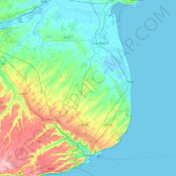
Name: Dover topographic map, elevation, terrain.
Location: Dover, Kent, England, United Kingdom (51.09719 1.14275 51.33238 1.40621)
Average elevation: 128 ft
Minimum elevation: -7 ft
Maximum elevation: 620 ft
Other topographic maps
Click on a map to view its topography, its elevation and its terrain.
Nelson Park
United Kingdom > England > Kent > Dover > St. Margaret's at Cliffe
Average elevation: 226 ft
White Cliffs of Dover
United Kingdom > England > Kent > Dover > St. Margaret's at Cliffe
Average elevation: 161 ft
Park Gate
United Kingdom > England > Kent > Folkestone and Hythe District > Elham
Average elevation: 427 ft