
Chautauqua County topographic map
Interactive map
Click on the map to display elevation.
Chautauqua County
The county is generally composed of rolling hills and valleys, with elevations ranging anywhere between 1100 and 2100 feet, although the land within a few miles of Lake Erie is generally flat and at an elevation of 1000 feet or lower. The lowest point in the county is Lake Erie, at 571 feet (174 meters), and the highest point is Gurnsey Benchmark at 2180 feet (664 meters).
About this map
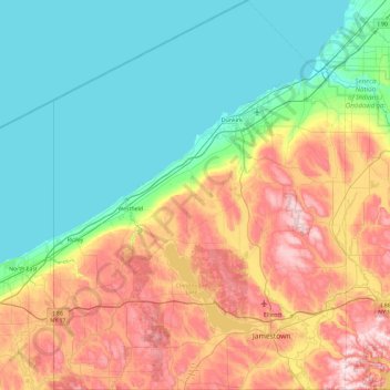
Name: Chautauqua County topographic map, elevation, terrain.
Location: Chautauqua County, New York, United States (41.99833 -79.76198 42.69246 -79.05921)
Average elevation: 1,076 ft
Minimum elevation: 558 ft
Maximum elevation: 2,188 ft
New York trails, hiking, mountain biking, running and outdoor activities
Other topographic maps
Click on a map to view its topography, its elevation and its terrain.
Central Park
United States > New York > New York County > New York
In June 1856, Fernando Wood appointed a "consulting board" of seven people, headed by author Washington Irving, to inspire public confidence in the proposed development. Wood hired military engineer Egbert Ludovicus Viele as the park's chief engineer, tasking him with a topographical survey of the site. The…
Average elevation: 85 ft
Niagara Escarpment
United States > New York > Niagara County > City of Lockport
Average elevation: 489 ft
South Setauket
United States > New York > Suffolk County > Town of Brookhaven
Average elevation: 144 ft
Holiday Valley
United States > New York > Cattaraugus County > Ellicottville
Average elevation: 1,788 ft
Central Park
United States > New York > New York County > New York
In June 1856, Fernando Wood appointed a "consulting board" of seven people, headed by author Washington Irving, to inspire public confidence in the proposed development. Wood hired military engineer Egbert Ludovicus Viele as the park's chief engineer, tasking him with a topographical survey of the site. The…
Average elevation: 85 ft
Coney Island
United States > New York > Saint Lawrence County > Town of Pierrepont
Average elevation: 571 ft
Fort Edward Feeder Canal
United States > New York > Washington County > Village of Fort Edward
Average elevation: 187 ft
Platte Clove
United States > New York > Greene County > Town of Hunter > Platte Clove Bruderhof
Average elevation: 1,886 ft
Buckhout Corners
United States > New York > Westchester County > Village of Briarcliff Manor
Average elevation: 367 ft
Mohegan Heights
United States > New York > Westchester County > City of Yonkers
Average elevation: 190 ft
Kaaterskill High Peak
United States > New York > Greene County > Town of Hunter
Average elevation: 2,789 ft
Cooper Lake
United States > New York > Ulster County > Town of Woodstock > Lake Hill
Average elevation: 1,204 ft
Harbor Hills Park
United States > New York > Nassau County > Village of Great Neck Estates
Average elevation: 33 ft
Woodcrest Bruderhof
United States > New York > Ulster County > Town of Esopus
Average elevation: 276 ft
Cowdens Corner
United States > New York > Chautauqua County > Town of Arkwright
Average elevation: 1,276 ft
Constantia Center
United States > New York > Oswego County > Town of Constantia
Average elevation: 554 ft
Dunham Hollow
United States > New York > Rensselaer County > Town of Nassau
Average elevation: 1,217 ft
South New Berlin
United States > New York > Chenango County > Town of New Berlin
Average elevation: 1,247 ft
Ellenburg Mountain
United States > New York > Clinton County > Town of Ellenburg
Average elevation: 2,238 ft
Woodcock Mountain
United States > New York > Saratoga County > Town of Hadley
Average elevation: 889 ft
Niagara Escarpment
United States > New York > Niagara County > City of Lockport
Average elevation: 489 ft
Lake Katonah
United States > New York > Westchester County > Town of Lewisboro
Average elevation: 417 ft
Mount Marcy
United States > New York > Essex County > Town of Keene
Mount Marcy is the highest point in the Adirondack Mountains and the U.S. state of New York, with an elevation of 5,343.1 feet (1,628.6 m). It is located in the town of Keene in Essex County. The mountain is in the heart of the High Peaks Wilderness Area in Adirondack Park. Like the surrounding Adirondack…
Average elevation: 4,229 ft
West Coxsackie
United States > New York > Greene County > Village of Coxsackie
Average elevation: 108 ft