
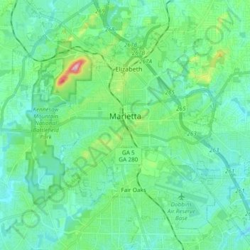
Marietta topographic map
Interactive map
Click on the map to display elevation.
About this map
Name: Marietta topographic map, elevation, terrain.
Location: Marietta, Cobb County, Georgia, United States (33.89559 -84.61681 34.00117 -84.46794)
Average elevation: 1,060 ft
Minimum elevation: 899 ft
Maximum elevation: 1,745 ft
Cobb County trails, hiking, mountain biking, running and outdoor activities
Other topographic maps
Click on a map to view its topography, its elevation and its terrain.
Vinings
United States > Georgia > Cobb County
Vinings features a varied topography characterized by rolling hills and lush, wooded areas that provide a picturesque backdrop to the community. The area is nestled alongside the Chattahoochee River, which contributes to the gentle slopes and valleys that define the landscape. Elevations in Vinings typically…
Average elevation: 922 ft
Kennesaw
United States > Georgia > Cobb County > Kennesaw
Kennesaw is located in northwestern Cobb County, bordered by the city of Acworth to the northwest. Kennesaw Mountain is located southeast of the city limits in the battlefield park. Its summit is the highest point in the Atlanta metro area, at an elevation of 1,808 feet (551 m) above sea level. The city was…
Average elevation: 1,043 ft