
Roosevelt Island topographic map
Interactive map
Click on the map to display elevation.
Roosevelt Island
The island is one of the southernmost locations in New York City where Fordham gneiss, a type of bedrock commonly found beneath the South Bronx, can be seen above ground. The gneiss outcropping was surrounded by dolomite, which was worn down by East River currents, creating the current island. The layer of bedrock is shallow and is covered by glacial till, and a 2012 study found no evidence of ponds or streams on the island. Since the 19th century, the island's natural topography has been modified drastically, and fill has been added to Roosevelt Island to increase its area. An ancient fault line, known as Cameron's Line, runs within the East River between Roosevelt Island and Queens.
About this map
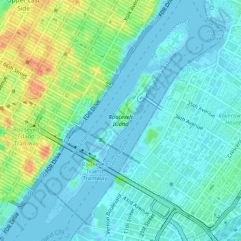
Name: Roosevelt Island topographic map, elevation, terrain.
Average elevation: 43 ft
Minimum elevation: -20 ft
Maximum elevation: 171 ft
New York County trails, hiking, mountain biking, running and outdoor activities
Other topographic maps
Click on a map to view its topography, its elevation and its terrain.
Brooklyn Bridge Park
United States > New York > New York County > New York
Brooklyn Bridge Park spans 85 acres (34 ha) of the East River waterfront in the Brooklyn Heights and Dumbo neighborhoods of Brooklyn. The park is divided into eleven sections: Piers 1 through 6; Fulton Ferry Landing; Brooklyn Bridge Plaza; Empire Fulton Ferry; Main Street; and John Street. Each of these…
Average elevation: 30 ft
Morningside Park
United States > New York > New York County > New York
Dutch settlers occupied Manhattan in the early 17th century and called the area around Morningside Park Vredendal, meaning 'peaceful dale'. The lowlands to the east were called Flacken by the Dutch, and were later translated to "Flats" in English. The land to the east was not settled initially because of its…
Average elevation: 66 ft
Hunter’s Point South Waterfront Park
United States > New York > New York County > New York
Average elevation: 16 ft