
Porterville topographic map
Interactive map
Click on the map to display elevation.
Porterville
Porterville, lying along the foothills of the Sierras at an elevation of 455 feet (139 m), is located on State Highway 65, 165 miles (266 km) north of Los Angeles, and 171 miles (275 km) east of the Pacific Coast. The city has a strategic central location to major markets and a ready access to major transportation routes.
About this map
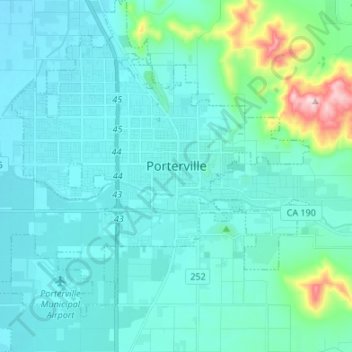
Name: Porterville topographic map, elevation, terrain.
Average elevation: 574 ft
Minimum elevation: 394 ft
Maximum elevation: 1,781 ft
Tulare County trails, hiking, mountain biking, running and outdoor activities
Other topographic maps
Click on a map to view its topography, its elevation and its terrain.
Mount Whitney
United States > California > Tulare County
Mount Whitney (Paiute: Too-man-i-goo-yah or Too-man-go-yah) is the highest mountain in the contiguous United States, with an elevation of 14,505 feet (4,421 m). It is in East–Central California, in the Sierra Nevada, on the boundary between California's Inyo and Tulare counties, and 84.6 miles (136.2 km)…
Average elevation: 12,805 ft
Mount Whitney
United States > California > Tulare County
Mount Whitney (Paiute: Tumanguya; Too-man-i-goo-yah) is the highest mountain in the contiguous United States and the Sierra Nevada, with an elevation of 14,505 feet (4,421 m). It is in East–Central California, on the boundary between California's Inyo and Tulare counties, 84.6 miles (136.2 km) west-northwest…
Average elevation: 12,805 ft
Allensworth
United States > California > Tulare County
Allensworth sits at an elevation of 213 feet (65 m), the same elevation as the huge and historically important Tulare Lake shore when it was full. The community is located in the ZIP Code 93219 and in the area code 661.
Average elevation: 207 ft
Mount Whitney
United States > California > Tulare County
Mount Whitney (Paiute: Tumanguya; Too-man-i-goo-yah) is the highest mountain in the contiguous United States and the Sierra Nevada, with an elevation of 14,505 feet (4,421 m). It is in East–Central California, on the boundary between California's Inyo and Tulare counties, 84.6 miles (136.2 km) west-northwest…
Average elevation: 12,805 ft
Poplar
United States > California > Tulare County > Poplar-Cotton Center > Poplar
Average elevation: 377 ft