
Oakhurst topographic map
Interactive map
Click on the map to display elevation.
Oakhurst
Oakhurst is located on the Fresno River 3 miles (5 km) south-southwest of Yosemite Forks, at an elevation of 2,274 feet (693 m). Its coordinates are 37°19′41″N 119°38′58″W / 37.32806°N 119.64944°W / 37.32806; -119.64944. It is located at the junction of state highways 41 and 49, at the southern end of California's Gold Country. Nearby communities include Ahwahnee, Coarsegold and Bass Lake.
About this map
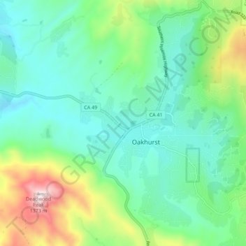
Name: Oakhurst topographic map, elevation, terrain.
Location: Oakhurst, Madera County, California, 93644, United States (37.29934 -119.67189 37.36699 -119.61735)
Average elevation: 2,746 ft
Minimum elevation: 2,113 ft
Maximum elevation: 4,544 ft
Madera County trails, hiking, mountain biking, running and outdoor activities