
Oakhurst topographic map
Click on the map to display elevation.
Oakhurst
Oakhurst is located on the Fresno River 3 miles (5 km) south-southwest of Yosemite Forks, at an elevation of 2,274 feet (693 m). Its coordinates are 37°19′41″N 119°38′58″W / 37.32806°N 119.64944°W / 37.32806; -119.64944. It is located at the junction of state highways 41 and 49, at the southern end of California's Gold Country. Nearby communities include Ahwahnee, Coarsegold and Bass Lake.
About this map
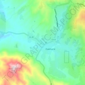
Name: Oakhurst topographic map, elevation, terrain.
Location: Oakhurst, Madera County, California, 93644, United States (37.29934 -119.67189 37.36699 -119.61735)
Average elevation: 2,746 ft
Minimum elevation: 2,113 ft
Maximum elevation: 4,544 ft
Madera County trails, hiking, mountain biking, running and outdoor activities
Other topographic maps
Click on a map to view its topography, its elevation and its terrain.
Coarsegold
United States > California > Madera County
Coarsegold is located on Highway 41 between Fresno and the southern entrance to Yosemite National Park, at an elevation of 2,218 ft (676 m). Fresno is 38 miles (61 km) to the south, and the south entrance of Yosemite is 23 miles (37 km) to the north. Nearby communities include Oakhurst 8 miles (13 km) to the…
Average elevation: 2,507 ft
Ansel Adams Wilderness
United States > California > Madera County
The Ansel Adams wilderness spans in elevation from 3,500 to 13,157 feet (1,067 to 4,010 m), forming the northern end of the High Sierra.
Average elevation: 8,222 ft
Coarsegold
United States > California > Madera County
Coarsegold is located on Highway 41 between Fresno and the southern entrance to Yosemite National Park, at an elevation of 2,218 ft (676 m). Fresno is 38 miles (61 km) to the south, and the south entrance of Yosemite is 23 miles (37 km) to the north. Nearby communities include Oakhurst 8 miles (13 km) to the…
Average elevation: 2,507 ft
Yosemite Lakes Park
United States > California > Madera County > Yosemite Lakes Park
Average elevation: 1,424 ft