Geolocate

Glenelg River topographic map

Interactive map

Click on the map to display elevation.

Glenelg River

The Glenelg River rises at an elevation of 760 metres (2,490 ft) above sea level below The Chimney Pots within the Grampians National Park, on the eastern slopes of the Victoria Range, and west of the Serra Range, within the Grampian Range. The river flows north through swampland before heading west, transversed by the Henty Highway, and then south where the river is impounded by the Rocklands Reservoir, formed by a concrete–walled gravity dam with embankment sections constructed in 1953. The reservoir has a maximum capacity of 348,300 megalitres (7.66×10¹⁰ imp gal; 9.20×10¹⁰ US gal). Leaving the dam wall, the river flows west through state forestry areas towards Balmoral, where the river is joined by the Salt, Mather, Yarramyljup, and Schofield Creeks, flowing to the east, north, then west of Balmoral, through the settlement of Harrow, where the river is met by another creek, also called Salt Creek. The Chetwynd River, draining the region north of Casterton and Coleraine, joins the Glenelg east of Burke Bridge. The Glenelg flows generally southwest, to the west of Dergholm State Park towards Dergholm, joined by a number of minor tributaries. From here the river flows south by east, through the town of Casterton, and south of which the 220-kilometre (140 mi) Wannon River forms its confluence with the Glenelg. Flowing south by west, the Glenelg flows through the Wilkin Flora and Fauna Reserve before heading due south, met by the Stokes River prior to flowing through the town of Dartmoor where the Crawford River forms its confluence with the Glenelg. Flowing south, then sharply west and crossing the state border into South Australia, the Glenelg flows through Donovans before heading east back into Victoria. The river reaches its mouth at Nelson and much of the latter course is through the Lower Glenelg National Park. From its highest point, the Glenelg River descends 760 metres (2,490 ft), joined by thirty–two named tributaries over its 350-kilometre (220 mi) course.

Wikipedia (CC-BY-SA 3.0)

About this map

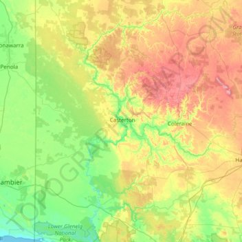
Name: Glenelg River topographic map, elevation, terrain.

Location: Glenelg River, Victoria, Australia (-38.06626 140.95607 -37.11349 141.95942)

Average elevation: 420 ft

Minimum elevation: -3 ft

Maximum elevation: 1,447 ft

Other topographic maps

Click on a map to view its topography, its elevation and its terrain.

City of Melbourne

Australia > Victoria

Average elevation: 59 ft

Bendigo

Australia > Victoria

Average elevation: 732 ft

Geelong

Australia > Victoria

Average elevation: 138 ft

Phillip Island

Australia > Victoria > Ventnor

Average elevation: 16 ft

Melbourne

Australia > Victoria

Melbourne is also prone to isolated convective showers forming when a cold pool crosses the state, especially if there is considerable daytime heating. These showers are often heavy and can include hail, squalls, and significant drops in temperature, but they often pass through very quickly with a rapid…

Average elevation: 607 ft

Mount Eliza

Australia > Victoria > Melbourne

Average elevation: 197 ft

Mornington District

Australia > Victoria > Melbourne

Average elevation: 164 ft

Port Phillip

Australia > Victoria

Port Phillip's mostly flat topography and moderate waves make perfect conditions for recreational swimming, kitesurfing, windsurfing, sailing, boating, snorkeling, scuba diving, stand up paddle boarding (SUP) and other sports.

Average elevation: 59 ft

Torquay

Australia > Victoria

Average elevation: 105 ft

Pakenham

Australia > Victoria > Melbourne

Average elevation: 184 ft

Ballarat

Australia > Victoria

Ballarat has a moderate oceanic climate (Köppen climate classification Cfb) with four distinct seasons. Its elevation, ranging between 400 and 630 metres (1,310 and 2,070 feet) above sea level, causes its mean monthly temperatures to tend to be on average 3 to 5 °C (5 to 9 °F) below those of Melbourne,…

Average elevation: 1,542 ft

Ashwood

Australia > Victoria > Melbourne

Average elevation: 223 ft

Mount Martha

Australia > Victoria > Melbourne

Average elevation: 131 ft

Werribee

Australia > Victoria > Melbourne

Average elevation: 72 ft

Rye

Australia > Victoria > Melbourne

Average elevation: 36 ft

Wimbledon Heights

Australia > Victoria

Average elevation: 135 ft

Neerim South

Australia > Victoria

Average elevation: 804 ft

Melbourne

Australia > Victoria

Melbourne is also prone to isolated convective showers forming when a cold pool crosses the state, especially if there is considerable daytime heating. These showers are often heavy and can include hail, squalls, and significant drops in temperature, but they often pass through very quickly with a rapid…

Average elevation: 161 ft

Dennington

Australia > Victoria

Average elevation: 43 ft

Dandenong Ranges National Park - Ferntree Gully

Australia > Victoria > Montrose

The topography consists of a series of ridges dissected by deeply cut streams. Sheltered gullies in the south of the range are home to temperate rain forest, fern gullies and Mountain Ash forest Eucalyptus regnans, whereas the drier ridges and exposed northern slopes are covered by dry sclerophyll forest of…

Average elevation: 1,132 ft

Inverloch

Australia > Victoria > Inverloch

Average elevation: 66 ft

Glen Waverley

Australia > Victoria

Average elevation: 338 ft

Warrnambool

Australia > Victoria

Average elevation: 62 ft

Heidelberg

Australia > Victoria > Melbourne

Average elevation: 161 ft

Mount Waverley District

Australia > Victoria

Average elevation: 328 ft

Howqua River

Australia > Victoria

Average elevation: 2,536 ft

Lalbert

Australia > Victoria

Average elevation: 299 ft

Gippsland

Australia > Victoria

Average elevation: 896 ft

Ocean Grove

Australia > Victoria > Ocean Grove

Average elevation: 52 ft

Eltham District

Australia > Victoria > Greensborough

Average elevation: 279 ft

Frankston

Australia > Victoria > Frankston

Olivers Hill is the most prominent elevation in Frankston which rises to 55 metres above sea level (180 feet) at its highest point in the suburb. Its origins date to approximately 415 to 360 million years ago. Its base is Mount Eliza Granite dating from the Devonian period, which was covered in lava tuffs in…

Average elevation: 118 ft

Sunbury

Australia > Victoria > Melbourne

Average elevation: 902 ft

Great Otway National Park

Australia > Victoria

Average elevation: 299 ft

Bright

Australia > Victoria

Average elevation: 1,804 ft

Daylesford

Australia > Victoria > Daylesford

Average elevation: 1,880 ft

Shepparton District

Australia > Victoria > Shepparton

Average elevation: 371 ft

Castlemaine

Australia > Victoria

The Castlemaine goldfields' legendary prosperity raised expectations of Castlemaine becoming Victoria's second city. That is reflected in imposing buildings erected in the town's first few years. Though the rich alluvial diggings were largely exhausted within 15–20 years causing the town's population to…

Average elevation: 1,047 ft

Grampians National Park

Australia > Victoria

Mount William is known within the gliding community for the "Grampians Wave", a weather phenomenon that sometimes enables glider pilots to reach extreme altitudes of the order of 28,000 ft (8,500 m). This predominantly occurs during the months of May, June, September and October when strong westerly winds flow…

Average elevation: 860 ft

Frankston

Australia > Victoria > Melbourne

Olivers Hill is the most prominent elevation in Frankston which rises to 55 metres above sea level (180 feet) at its highest point in the suburb. Its origins date to approximately 415 to 360 million years ago. Its base is Mount Eliza Granite dating from the Devonian period, which was covered in lava tuffs in…

Average elevation: 131 ft

Beulah

Australia > Victoria

Average elevation: 299 ft

Wodonga

Australia > Victoria

Average elevation: 627 ft

Mount Dandenong

Australia > Victoria > Melbourne

Mount Dandenong has a cool oceanic climate (Cfb), with cool to mild summers and cold, damp winters. Daytime temperatures are usually 4−6 °C cooler than downtown Melbourne due to its elevation and distance from the urban heat island effect of Melbourne. It is significantly cloudier than Melbourne,…

Average elevation: 1,296 ft

Banksia Peninsula

Australia > Victoria

Average elevation: 20 ft

Noble Park North

Australia > Victoria > Melbourne

Average elevation: 210 ft

Mildura

Australia > Victoria > Mildura

Average elevation: 171 ft

Echuca

Australia > Victoria

Average elevation: 328 ft

Point Cook

Australia > Victoria > Melbourne

Average elevation: 26 ft

Bonnie Doon

Australia > Victoria

Average elevation: 1,394 ft

Melbourne District

Australia > Victoria > Melbourne

Average elevation: 66 ft

Kiewa

Australia > Victoria

Average elevation: 1,033 ft

Blackburn

Australia > Victoria

Average elevation: 338 ft

Waranga

Australia > Victoria

Average elevation: 390 ft

Beechworth

Australia > Victoria > Beechworth

Average elevation: 1,749 ft

Nhill

Australia > Victoria

Average elevation: 466 ft

Ballan

Australia > Victoria

Ballan has a oceanic climate (Köppen: Cfb), with very mild, relatively dry summers and cool, slightly wetter winters. Influenced by its elevation (442 m (1,450 ft)); average maxima vary from 24.6 °C (76.3 °F) in January to 10.2 °C (50.4 °F) in July, while average minima fluctuate between 10.3 °C (50.5…

Average elevation: 1,627 ft

Spring Gully

Australia > Victoria

Average elevation: 909 ft

Mount Macedon

Australia > Victoria

Average elevation: 2,477 ft

Croydon South

Australia > Victoria > Melbourne

Average elevation: 387 ft

Dewhurst

Australia > Victoria > Melbourne

Average elevation: 627 ft

Langsborough

Australia > Victoria

Average elevation: 10 ft

Lilydale

Australia > Victoria > Lilydale

Average elevation: 436 ft

Haywood Hill Reserve

Australia > Victoria > Seymour

Average elevation: 505 ft

Cheshunt South

Australia > Victoria

Average elevation: 2,129 ft

Digby

Australia > Victoria

Average elevation: 499 ft

Bittern

Australia > Victoria > Melbourne

Average elevation: 79 ft

All Nations Park

Australia > Victoria > Melbourne

Average elevation: 161 ft

Yarra Ranges National Park

Australia > Victoria > Melbourne

Average elevation: 1,526 ft

Doncaster East

Australia > Victoria > Melbourne

Average elevation: 292 ft

Berwick

Australia > Victoria > Harkaway

Average elevation: 190 ft

Cann River

Australia > Victoria

Average elevation: 364 ft

Kyneton

Australia > Victoria

Average elevation: 1,654 ft

Yuulong

Australia > Victoria

Average elevation: 522 ft

Metung

Australia > Victoria

Average elevation: 56 ft

Coburg

Australia > Victoria > Melbourne

Average elevation: 187 ft

Wattle Hill

Australia > Victoria

Average elevation: 784 ft

Northcote

Australia > Victoria > Melbourne

Average elevation: 144 ft

Lyonville

Australia > Victoria

Average elevation: 2,425 ft

Emerald

Australia > Victoria > Melbourne

Average elevation: 738 ft

Mount Buller

Australia > Victoria

Due to its far south-western location in the alpine region, Mount Buller is more susceptible to cold airmasses which allow it to record some of the lowest maximum temperatures and daytime readings in the country, despite being considerably lower in elevation than other mountain sites to the north-east. On 5…

Average elevation: 2,703 ft

Murrabit West

Australia > Victoria

Average elevation: 243 ft

Carpendeit

Australia > Victoria

Average elevation: 492 ft

Murrabit

Australia > Victoria

Average elevation: 246 ft

Kinglake

Australia > Victoria > Kinglake

Average elevation: 1,365 ft

Talgarno

Australia > Victoria

Average elevation: 1,037 ft

Drouin

Australia > Victoria > Drouin

Average elevation: 404 ft

Heathcote South

Australia > Victoria

Average elevation: 988 ft

Gembrook

Australia > Victoria > Melbourne

Average elevation: 735 ft

Culgoa

Australia > Victoria

Average elevation: 272 ft

Marysville

Australia > Victoria > Marysville

Average elevation: 1,611 ft

Wangaratta

Australia > Victoria > Wangaratta

Average elevation: 617 ft

Yambuk

Australia > Victoria

Average elevation: 49 ft

Manangatang

Australia > Victoria

Average elevation: 194 ft

Kaniva

Australia > Victoria

Average elevation: 446 ft

East Framlingham

Australia > Victoria

Average elevation: 354 ft

Yackandandah

Australia > Victoria

Average elevation: 1,539 ft

Yarra Valley

Australia > Victoria > Melbourne

The Yarra Valley is the region surrounding the Yarra River in Victoria, Australia. The river originates approximately 240 km (150 mi) east of the Melbourne central business district and flows towards it and out into Port Phillip Bay. The name Yarra Valley is used in reference to the upper regions surrounding…

Average elevation: 1,001 ft

Euroa

Australia > Victoria

Average elevation: 817 ft