
Peak District National Park topographic map
Interactive map
Click on the map to display elevation.
About this map
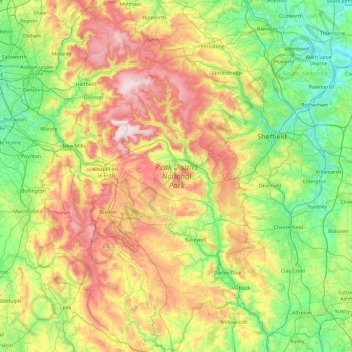
Name: Peak District National Park topographic map, elevation, terrain.
Average elevation: 738 ft
Minimum elevation: 39 ft
Maximum elevation: 2,087 ft
Other topographic maps
Click on a map to view its topography, its elevation and its terrain.
Crackley
United Kingdom > England > Staffordshire > Newcastle-under-Lyme > Chesterton
Average elevation: 545 ft
Kingsley Holt
United Kingdom > England > Staffordshire > Staffordshire Moorlands
Average elevation: 604 ft
Burton-on-Trent
United Kingdom > England > Staffordshire > East Staffordshire
Burton is about 109 miles (175 km) north west of London, about 30 miles north east of Birmingham, the UK's second largest city and about 23 miles east of the county town Stafford. It is at the easternmost border of the county of Staffordshire with Derbyshire, its suburbs and the course of the River Trent…
Average elevation: 226 ft
Gratwich
United Kingdom > England > Staffordshire > East Staffordshire > Kingstone
Average elevation: 469 ft
Boundary
United Kingdom > England > Staffordshire > Staffordshire Moorlands > Boundary
Average elevation: 630 ft
Thorncliffe
United Kingdom > England > Staffordshire > Staffordshire Moorlands > Thorncliffe
Average elevation: 1,024 ft
Swan Bank
United Kingdom > England > Staffordshire > Newcastle-under-Lyme > Madeley > Swan Bank
Average elevation: 443 ft