
Sleman topographic map
Interactive map
Click on the map to display elevation.
About this map
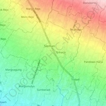
Name: Sleman topographic map, elevation, terrain.
Average elevation: 814 ft
Minimum elevation: 499 ft
Maximum elevation: 1,306 ft
Other topographic maps
Click on a map to view its topography, its elevation and its terrain.
Sepanjang Beach
Indonesia > Special Region of Yogyakarta > Gunungkidul Regency > Kemadang
Average elevation: 49 ft
Kayen
Indonesia > Special Region of Yogyakarta > Sleman Regency > Condongcatur
Average elevation: 597 ft
Ijo Temple
Indonesia > Special Region of Yogyakarta > Sleman Regency > Sambirejo
The temple compound is located in Groyokan hamlet, Sambirejo village, Kecamatan Prambanan, Sleman Regency, Yogyakarta. The temple's name derived from its location, the Gumuk Ijo hill. The temple compound stood on western slope of the hill, in a quiet region east of Yogyakarta, around 4 kilometers southeast…
Average elevation: 764 ft
Karangmalang
Indonesia > Special Region of Yogyakarta > Sleman Regency > Catur tunggal
Average elevation: 456 ft
Janti
Indonesia > Special Region of Yogyakarta > Sleman Regency > Catur tunggal
Average elevation: 407 ft
Cepetsari Glagahharjo
Indonesia > Special Region of Yogyakarta > Sleman Regency > Glagah Harjo
Average elevation: 1,640 ft
Gunung Merapi
Indonesia > Special Region of Yogyakarta > Sleman Regency > Hargobinangun
Average elevation: 7,411 ft
Depok Beach
Indonesia > Special Region of Yogyakarta > Bantul Regency > Parangtritis
Average elevation: 10 ft
Siraman
Indonesia > Special Region of Yogyakarta > Gunung Kidul Regency > Siraman
Average elevation: 581 ft
Candi Binangun
Indonesia > Special Region of Yogyakarta > Sleman Regency > Candibinangun
Average elevation: 1,486 ft
Sendang Tirto
Indonesia > Special Region of Yogyakarta > Sleman Regency > Sendangtirto
Average elevation: 302 ft
Laut Bekah
Indonesia > Special Region of Yogyakarta > Gunung Kidul Regency > Girikarto
Average elevation: 125 ft
Gerojogan Lepo
Indonesia > Special Region of Yogyakarta > Bantul Regency > Dlingo
Average elevation: 436 ft
Sleman
Indonesia > Special Region of Yogyakarta > Sleman Regency > Triharjo
Average elevation: 1,122 ft
Ngipiksari
Indonesia > Special Region of Yogyakarta > Sleman Regency > Hargobinangun > Kaliurang
Average elevation: 2,605 ft
Wisdom park
Indonesia > Special Region of Yogyakarta > Sleman Regency > Catur tunggal
Average elevation: 446 ft
Kaliurang
Indonesia > Special Region of Yogyakarta > Sleman Regency > Hargobinangun
Average elevation: 2,815 ft
Condong Catur
Indonesia > Special Region of Yogyakarta > Sleman Regency > Condongcatur > Condong Catur
Average elevation: 535 ft
Embung Tambakboyo
Indonesia > Special Region of Yogyakarta > Sleman Regency > Condongcatur > Condongcatur
Average elevation: 538 ft