
Make a donation
Gear up for your next adventure:
As an Amazon Associate, this site earns from qualifying purchases at no extra cost to you.
Yogyakarta topographic map
Click on the map to display elevation.
Make a donation
Gear up for your next adventure:
As an Amazon Associate, this site earns from qualifying purchases at no extra cost to you.
About this map
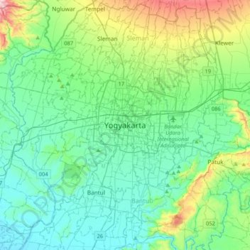
Name: Yogyakarta topographic map, elevation, terrain.
Location: Yogyakarta, Special Region of Yogyakarta, Java, Indonesia (-7.96119 110.20492 -7.64119 110.52492)
Average elevation: 515 ft
Minimum elevation: 16 ft
Maximum elevation: 2,382 ft
Make a donation
Gear up for your next adventure:
As an Amazon Associate, this site earns from qualifying purchases at no extra cost to you.
Other topographic maps
Click on a map to view its topography, its elevation and its terrain.
Baleharjo
Indonesia > Special Region of Yogyakarta > Gunungkidul Regency > Wonosari
Average elevation: 587 ft
Make a donation
Gear up for your next adventure:
As an Amazon Associate, this site earns from qualifying purchases at no extra cost to you.
Make a donation
Gear up for your next adventure:
As an Amazon Associate, this site earns from qualifying purchases at no extra cost to you.
Selang
Indonesia > Special Region of Yogyakarta > Gunungkidul Regency > Wonosari
Average elevation: 617 ft
Make a donation
Gear up for your next adventure:
As an Amazon Associate, this site earns from qualifying purchases at no extra cost to you.
Waterboom Jogja
Indonesia > Special Region of Yogyakarta > Sleman Regency > Wedomartani
Average elevation: 577 ft
Make a donation
Gear up for your next adventure:
As an Amazon Associate, this site earns from qualifying purchases at no extra cost to you.
Pantai Timang
Indonesia > Special Region of Yogyakarta > Gunungkidul Regency > Tepus > Purwodadi
Average elevation: 131 ft
Make a donation
Gear up for your next adventure:
As an Amazon Associate, this site earns from qualifying purchases at no extra cost to you.
Mount Merapi National Park
Indonesia > Special Region of Yogyakarta > Sleman Regency > Hargobinangun
Average elevation: 3,773 ft
Make a donation
Gear up for your next adventure:
As an Amazon Associate, this site earns from qualifying purchases at no extra cost to you.
Make a donation
Gear up for your next adventure:
As an Amazon Associate, this site earns from qualifying purchases at no extra cost to you.
Make a donation
Gear up for your next adventure:
As an Amazon Associate, this site earns from qualifying purchases at no extra cost to you.
Wisdom park
Indonesia > Special Region of Yogyakarta > Sleman Regency > Catur tunggal
Average elevation: 446 ft
Make a donation
Gear up for your next adventure:
As an Amazon Associate, this site earns from qualifying purchases at no extra cost to you.
Make a donation
Gear up for your next adventure:
As an Amazon Associate, this site earns from qualifying purchases at no extra cost to you.
Sepanjang Beach
Indonesia > Special Region of Yogyakarta > Gunungkidul Regency > Kemadang
Average elevation: 49 ft
Make a donation
Gear up for your next adventure:
As an Amazon Associate, this site earns from qualifying purchases at no extra cost to you.
Make a donation
Gear up for your next adventure:
As an Amazon Associate, this site earns from qualifying purchases at no extra cost to you.
Make a donation
Gear up for your next adventure:
As an Amazon Associate, this site earns from qualifying purchases at no extra cost to you.
Make a donation
Gear up for your next adventure:
As an Amazon Associate, this site earns from qualifying purchases at no extra cost to you.
Make a donation
Gear up for your next adventure:
As an Amazon Associate, this site earns from qualifying purchases at no extra cost to you.
Make a donation
Gear up for your next adventure:
As an Amazon Associate, this site earns from qualifying purchases at no extra cost to you.
Make a donation
Gear up for your next adventure:
As an Amazon Associate, this site earns from qualifying purchases at no extra cost to you.
Depok Beach
Indonesia > Special Region of Yogyakarta > Bantul Regency > Parangtritis
Average elevation: 10 ft
Make a donation
Gear up for your next adventure:
As an Amazon Associate, this site earns from qualifying purchases at no extra cost to you.
taman kampus ISI
Indonesia > Special Region of Yogyakarta > Bantul Regency > Sewon > Panggungharjo > Puri Sewon Asri
Average elevation: 217 ft
Make a donation
Gear up for your next adventure:
As an Amazon Associate, this site earns from qualifying purchases at no extra cost to you.
Make a donation
Gear up for your next adventure:
As an Amazon Associate, this site earns from qualifying purchases at no extra cost to you.
Ijo Temple
Indonesia > Special Region of Yogyakarta > Sleman Regency > Sambirejo
The temple compound is located in Groyokan hamlet, Sambirejo village, Kecamatan Prambanan, Sleman Regency, Yogyakarta. The temple's name derived from its location, the Gumuk Ijo hill. The temple compound stood on western slope of the hill, in a quiet region east of Yogyakarta, around 4 kilometers southeast…
Average elevation: 764 ft
Make a donation
Gear up for your next adventure:
As an Amazon Associate, this site earns from qualifying purchases at no extra cost to you.
Make a donation
Gear up for your next adventure:
As an Amazon Associate, this site earns from qualifying purchases at no extra cost to you.
Make a donation
Gear up for your next adventure:
As an Amazon Associate, this site earns from qualifying purchases at no extra cost to you.
Make a donation
Gear up for your next adventure:
As an Amazon Associate, this site earns from qualifying purchases at no extra cost to you.
Make a donation
Gear up for your next adventure:
As an Amazon Associate, this site earns from qualifying purchases at no extra cost to you.