
Gretna topographic map
Interactive map
Click on the map to display elevation.
About this map
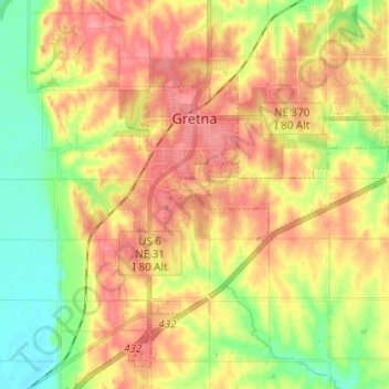
Name: Gretna topographic map, elevation, terrain.
Location: Gretna, Sarpy County, Nebraska, 68028, United States (41.08729 -96.26300 41.16951 -96.13913)
Average elevation: 1,191 ft
Minimum elevation: 1,056 ft
Maximum elevation: 1,306 ft
Other topographic maps
Click on a map to view its topography, its elevation and its terrain.
Chalco
United States > Nebraska > Sarpy County
Chalco, Sarpy County, Nebraska, 68138, United States
Average elevation: 1,135 ft
Bellevue
United States > Nebraska > Sarpy County
Bellevue, Sarpy County, Nebraska, United States
Average elevation: 1,033 ft
La Vista
United States > Nebraska > Sarpy County
La Vista, Sarpy County, Nebraska, 68128, United States
Average elevation: 1,083 ft
Fontenelle Forest
United States > Nebraska > Sarpy County > Bellevue
Fontenelle Forest, Bellevue, Sarpy County, Nebraska, 68123, United States
Average elevation: 1,037 ft
Papillion
United States > Nebraska > Sarpy County
Papillion, Sarpy County, Nebraska, 68046, United States
Average elevation: 1,109 ft
Prairie Queen Recreation Area
United States > Nebraska > Sarpy County > Papillion
Prairie Queen Recreation Area, Papillion, Sarpy County, Nebraska, United States
Average elevation: 1,135 ft
Springfield
United States > Nebraska > Sarpy County > Springfield
Springfield, Sarpy County, Nebraska, 68059, United States
Average elevation: 1,129 ft