
Murphys topographic map
Interactive map
Click on the map to display elevation.
Murphys
"MURPHY'S CAMP is a curious old mining-town in Calaveras County, at an elevation of 2,400 feet (730 m) above the sea, situated like a nest in the center of a rough, gravelly region, rich in gold. Granites, slates, lavas, limestone, iron ores, quartz veins, auriferous gravels, remnants of dead fire-rivers and dead water-rivers are developed here side by side within a radius of a few miles, and placed invitingly open before the student like a book, while the people and the region beyond the camp furnish mines of study of never-failing interest and variety."
About this map
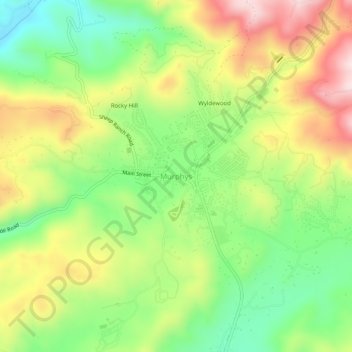
Name: Murphys topographic map, elevation, terrain.
Average elevation: 2,303 ft
Minimum elevation: 1,755 ft
Maximum elevation: 2,995 ft
Calaveras County trails, hiking, mountain biking, running and outdoor activities
Other topographic maps
Click on a map to view its topography, its elevation and its terrain.
Dorrington
United States > California > Calaveras County
According to the United States Census Bureau, the CDP has a total area of 3.7 square miles (9.6 km2), 99.86% of it land. The elevation is 4,800 feet ASL.
Average elevation: 4,803 ft
Calaveras Big Trees State Park
United States > California > Calaveras County
Average elevation: 4,511 ft
Rail Road Flat
United States > California > Calaveras County
This historic mining town, elevation 2,600 feet (788 m), was named after primitive mule-drawn ore cars used here. There was never actually a railroad here. The town was established in 1849. It was the site of an Indian council as well as the center of rich placer and quartz mining. Its largest producer was the…
Average elevation: 2,726 ft