
Make a donation
Gear up for your next adventure:
As an Amazon Associate, this site earns from qualifying purchases at no extra cost to you.
Rail Road Flat topographic map
Click on the map to display elevation.
Make a donation
Gear up for your next adventure:
As an Amazon Associate, this site earns from qualifying purchases at no extra cost to you.
Rail Road Flat
This historic mining town, elevation 2,600 feet (788 m), was named after primitive mule-drawn ore cars used here. There was never actually a railroad here. The town was established in 1849. It was the site of an Indian council as well as the center of rich placer and quartz mining. Its largest producer was the Petticoat Mine. The post office was established in 1857, closed in 1858, and re-established in 1869 and the Edwin Taylor store built in 1867. The town's population was decimated in 1880 by black fever.
Make a donation
Gear up for your next adventure:
As an Amazon Associate, this site earns from qualifying purchases at no extra cost to you.
About this map
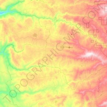
Name: Rail Road Flat topographic map, elevation, terrain.
Average elevation: 2,726 ft
Minimum elevation: 1,148 ft
Maximum elevation: 4,081 ft
Calaveras County trails, hiking, mountain biking, running and outdoor activities
Make a donation
Gear up for your next adventure:
As an Amazon Associate, this site earns from qualifying purchases at no extra cost to you.
Other topographic maps
Click on a map to view its topography, its elevation and its terrain.
Make a donation
Gear up for your next adventure:
As an Amazon Associate, this site earns from qualifying purchases at no extra cost to you.
Make a donation
Gear up for your next adventure:
As an Amazon Associate, this site earns from qualifying purchases at no extra cost to you.
Campo Seco
United States > California > Calaveras County
Campo Seco (Spanish for "Dry Field") is an unincorporated community in Calaveras County, California. It sits at an elevation of 564 feet (172 m) above sea level and is located at 38°13′38″N 120°51′12″W / 38.22722°N 120.85333°W / 38.22722; -120.85333. The community is in ZIP code 95226 and area code 209.
Average elevation: 607 ft
Make a donation
Gear up for your next adventure:
As an Amazon Associate, this site earns from qualifying purchases at no extra cost to you.
Oak Park Estates
United States > California > Calaveras County > San Andreas
Average elevation: 1,165 ft
Make a donation
Gear up for your next adventure:
As an Amazon Associate, this site earns from qualifying purchases at no extra cost to you.
Make a donation
Gear up for your next adventure:
As an Amazon Associate, this site earns from qualifying purchases at no extra cost to you.