Geolocate

Kocaeli topographic map

Interactive map

Click on the map to display elevation.

About this map

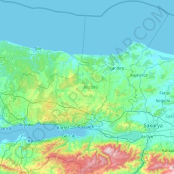
Name: Kocaeli topographic map, elevation, terrain.

Location: Kocaeli, Marmara Region, Turkey (40.52354 29.31573 41.41700 30.51173)

Average elevation: 574 ft

Minimum elevation: -3 ft

Maximum elevation: 5,131 ft

Other topographic maps

Click on a map to view its topography, its elevation and its terrain.

Istanbul

Turkey > Fatih

Istanbul, located in northwestern Turkey, is a city that is uniquely situated across two continents, Europe and Asia, divided by the Bosphorus Strait. The city’s topography is characterized by a complex blend of hills, valleys, and coastal plains, which create a varied and scenic landscape. The European side…

Average elevation: 187 ft

Bursa

Turkey > Osmangazi

Average elevation: 1,962 ft

Ankara

Turkey > Ankara > Çankaya

Ankara has a cold semi-arid climate (Köppen climate classification: BSk). Under the Trewartha climate classification, Ankara has a temperate humid continental climate (Dc). Due to its elevation and inland location, Ankara has cold and snowy winters, and hot and dry summers. Rainfall occurs mostly during the…

Average elevation: 3,550 ft

İzmir

Turkey > Konak

Average elevation: 863 ft

Antalya

Turkey > Muratpaşa

While the city itself only has modest elevation changes, Antalya has high mountains in all directions to its interior. With moisture being trapped, the local climate thus has high winter rainfall, while the interior bay setting result in very hot summers for a coastal city.

Average elevation: 384 ft

Istanbul

Turkey > Fatih

Istanbul, located in northwestern Turkey, is a city that is uniquely situated across two continents, Europe and Asia, divided by the Bosphorus Strait. The city’s topography is characterized by a complex blend of hills, valleys, and coastal plains, which create a varied and scenic landscape. The European side…

Average elevation: 187 ft

Dolmabahçe

Turkey > Hınıs

Average elevation: 6,181 ft

Çaldağ

Turkey > Giresun

Average elevation: 2,520 ft

Halfeli

Turkey > Iğdır

Average elevation: 2,890 ft

Özlüce

Turkey > Tarsus

Average elevation: 151 ft

Kızılcaova

Turkey > Akdağmadeni

Average elevation: 6,430 ft

Gümürdülü

Turkey > Ceyhan

Average elevation: 249 ft

Kıcak

Turkey > Aladağ

Average elevation: 3,379 ft

Eşmepınar

Turkey > Çayırlı

Average elevation: 5,751 ft

Özlüce

Turkey > Menteşe

Average elevation: 3,501 ft

Kümbet

Turkey > Dereli

Average elevation: 5,538 ft

Bozat

Turkey > Piraziz

Average elevation: 1,903 ft

Bahariye Adaları

Turkey > Istanbul

Average elevation: 144 ft

Eşmepınar

Turkey > Başkale

Average elevation: 7,772 ft

Barla

Turkey > Eğirdir

Average elevation: 3,924 ft

Kurna

Turkey > Burdur Merkez

Average elevation: 3,930 ft

Çatalhöyük

Turkey > Ceyhan

Average elevation: 105 ft

Kılıçlı

Turkey > Keşap

Average elevation: 453 ft

Cumhuriyet Meydanı

Turkey > Kocasinan

Average elevation: 3,468 ft

Diyarbakır

Turkey > Sur

Average elevation: 2,297 ft

Kartaltepe

Turkey > Sur

Average elevation: 2,087 ft

Söğütlü

Turkey > Çilimli

Average elevation: 554 ft

Trabzon

Turkey > Ortahisar

Average elevation: 791 ft

Tekkeköy

Turkey > Kastamonu

Average elevation: 4,160 ft

Gölköy

Turkey > Kastamonu

Average elevation: 2,497 ft

Kargıcak

Turkey > Alanya

Average elevation: 177 ft

Ekolojik Köprü

Turkey > Körfez > Kutluca Mahallesi

Average elevation: 1,512 ft

Coşandere

Turkey > Maçka

Average elevation: 2,687 ft

Istanbul

Turkey > Istanbul > Fatih

Istanbul, located in northwestern Turkey, is a city that is uniquely situated across two continents, Europe and Asia, divided by the Bosphorus Strait. The city’s topography is characterized by a complex blend of hills, valleys, and coastal plains, which create a varied and scenic landscape. The European side…

Average elevation: 187 ft

Arıklı

Turkey > Kızıltepe

Average elevation: 1,457 ft

Tozkoparan

Turkey > Pertek

Average elevation: 4,642 ft

Kısıklı

Turkey > Yüksekova

Average elevation: 7,526 ft

Uzunkale

Turkey > Manavgat

Average elevation: 515 ft

Dereiçi

Turkey > Savur

Average elevation: 3,507 ft

Allahdiyen

Turkey > Salihli

Average elevation: 1,732 ft

Habiller

Turkey > Havsa

Average elevation: 410 ft

Uludağ

Turkey > Osmangazi

Uludağ (Turkish pronunciation: [ˈuɫudaː]), the ancient Mysian or Bithynian Olympus (Greek: Όλυμπος), is a mountain in Bursa Province, Turkey, with an elevation of 2,543 m (8,343 ft).

Average elevation: 7,431 ft

Hazındak Yaylası

Turkey > Çamlıhemşin > Ortan

Average elevation: 6,289 ft

Yeşil Dumlupınar

Turkey > Ilgaz

Average elevation: 4,816 ft

Ortayol

Turkey > Başkale

Average elevation: 7,336 ft

Çamlıdere Dam

Turkey > Ankara > Kızılcahamam

Average elevation: 3,261 ft

Büyükbelen

Turkey > Saruhanlı

Average elevation: 1,198 ft

Alazlı

Turkey > Düzköy

Average elevation: 3,612 ft

Yazlık

Turkey > Adıyaman

Average elevation: 1,860 ft

Kocapınar

Turkey > Cizre

Average elevation: 1,952 ft

Fındıklı Aksu

Turkey > Düzce

Average elevation: 1,903 ft

Gaziantep

Turkey > Şahinbey

The plan introduced several important changes to the city's transportation network. One of the most important was the addition of a rail line to connect Gaziantep to the national rail system. Up to now, Turkish railway construction had ignored Gaziantep (partly because of its mountainous surroundings); a…

Average elevation: 2,887 ft

Bastak

Turkey > Daday

Average elevation: 3,428 ft

Kocagöl

Turkey > Manyas

Average elevation: 79 ft

Kumaşkaya

Turkey > Pazaryolu

Average elevation: 6,703 ft

Kebeli

Turkey > Cizre

Average elevation: 1,909 ft

Karacaören

Turkey > Kars

Average elevation: 5,810 ft

Örnekköy

Turkey > Yüksekova

Average elevation: 6,473 ft

Okurcalar

Turkey > Alanya

Average elevation: 171 ft

Civil

Turkey > Tirebolu

Average elevation: 650 ft

Yaka

Turkey > Düzce

Average elevation: 876 ft

Adana

Turkey > Seyhan

Average elevation: 200 ft

Günbağı

Turkey > Erzincan

Average elevation: 4,528 ft

Gölyazı

Turkey > Tuşba

Average elevation: 6,276 ft

Aydıncık

Turkey > Gazipaşa

Average elevation: 322 ft

Çınarlık

Turkey > Çarşamba

Average elevation: 20 ft

Aran

Turkey > Artuklu

Average elevation: 3,455 ft

Bayatlar

Turkey > Yenice

Average elevation: 748 ft

Doğanlı

Turkey > Çumra

Average elevation: 3,376 ft

Taurus Mountains

Turkey

The mountains have a Mediterranean climate, with dry summers and rainy winters. Temperatures vary with elevation, with warm winters on the lower coastal slopes and cold winters in the high mountains and in the interior.

Average elevation: 2,717 ft

Oylum

Turkey > Sürmene

Average elevation: 3,045 ft

Kızılkeçili

Turkey > Çanakkale Merkez

Average elevation: 833 ft

Aşağı Çalıca

Turkey > Hendek

Average elevation: 180 ft

Mount Judi

Turkey > Şırnak

The Arabic word al-Jūdiyy (ٱلْجُودِيّ), originates from the Syriac word Gudo (ܓܘܕܐ) meaning "Mounds" or "Elevations". The relation of some of the spellings is clear. The origin of Judi is less clear. It is usually interpreted as a corrupted version of the same name, via Al-Gurdi (Reynolds 2004).…

Average elevation: 6,247 ft

Ilgaz Dağı

Turkey > Kastamonu

Average elevation: 7,093 ft

Kavaklı

Turkey > Çatalzeytin

Average elevation: 3,255 ft

Narpızlı Yaylası

Turkey > Konyaaltı

Average elevation: 4,984 ft

Kendirli

Turkey > Bilecik

Average elevation: 2,651 ft

Yukarıpelitözü

Turkey > Çankırı

Average elevation: 2,749 ft

Abbasağa Parkı

Turkey > Beşiktaş

Average elevation: 141 ft

Yapağılı

Turkey > Dinar

Average elevation: 3,094 ft

Kaşlıca

Turkey > Çatalzeytin

Average elevation: 499 ft

Mahmutlar

Turkey > Yahşihan

Average elevation: 2,894 ft

Boztepe

Turkey > Adıyaman

Average elevation: 1,995 ft

Karacaali

Turkey > Yenişehir

Average elevation: 853 ft

Saraycık

Turkey > Kastamonu

Average elevation: 3,773 ft

Üzümlü

Turkey > Alanya

Average elevation: 1,437 ft

Kılavuzlu

Turkey > Onikişubat

Average elevation: 1,827 ft

Ankara

Turkey > Ankara > Çankaya

Ankara has a cold semi-arid climate (Köppen climate classification: BSk). Under the Trewartha climate classification, Ankara has a temperate humid continental climate (Dc). Due to its elevation and inland location, Ankara has cold and snowy winters, and hot and dry summers. Rainfall occurs mostly during the…

Average elevation: 3,550 ft

Çaykışla

Turkey > Emirdağ

Average elevation: 4,311 ft

Muradiye

Turkey > Sapanca

Average elevation: 1,076 ft

Kavakoluğu

Turkey > Gülnar

Average elevation: 1,834 ft

Demirtaş

Turkey > Alanya

Average elevation: 282 ft

Karaağaç

Turkey > Çorum

Average elevation: 4,016 ft

Kapuzbashi Waterfalls

Turkey > Yahyalı > Kapuzbaşı

Average elevation: 3,038 ft

Gülek

Turkey > Tarsus

Gülek is situated along a valley on the Taurus Mountains. The main pass of these mountains, which is known as Gülek Pass (ancient Cilician Gates), is just east of the town. The average altitude of the town is about 1,150 metres (3,770 ft).

Average elevation: 3,799 ft

Antalya

Turkey > Muratpaşa

While the city itself only has modest elevation changes, Antalya has high mountains in all directions to its interior. With moisture being trapped, the local climate thus has high winter rainfall, while the interior bay setting results in very hot summers for a coastal city.

Average elevation: 384 ft

Korucuk

Turkey > Saraydüzü

Average elevation: 1,342 ft

Aknehir

Turkey > Defne

Average elevation: 436 ft