
Radostín nad Oslavou topographic map
Interactive map
Click on the map to display elevation.
About this map
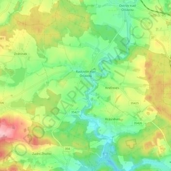
Name: Radostín nad Oslavou topographic map, elevation, terrain.
Average elevation: 1,808 ft
Minimum elevation: 1,585 ft
Maximum elevation: 2,152 ft
Other topographic maps
Click on a map to view its topography, its elevation and its terrain.
Lány
Czechia > Southeast > Kraj Vysočina
Lány, okres Havlíčkův Brod, Kraj Vysočina, Southeast, Czechia
Average elevation: 1,539 ft
Třebíč
Czechia > Southeast > Kraj Vysočina
Třebíč, okres Třebíč, Kraj Vysočina, Southeast, 674 01, Czechia
Average elevation: 1,572 ft
Nové Město na Moravě
Czechia > Southeast > Kraj Vysočina
Nové Město na Moravě, okres Žďár nad Sázavou, Kraj Vysočina, Southeast, 592 31, Czechia
Average elevation: 2,149 ft
Pávov
Czechia > Southeast > Kraj Vysočina > Jihlava
Pávov, Jihlava, okres Jihlava, Kraj Vysočina, Southeast, 588 11, Czechia
Average elevation: 1,722 ft
Křídla
Czechia > Southeast > Kraj Vysočina > Křídla
Křídla, okres Žďár nad Sázavou, Kraj Vysočina, Southeast, Czechia
Average elevation: 1,969 ft
Popůvky
Czechia > Southeast > Kraj Vysočina > Popůvky
Popůvky, okres Třebíč, Kraj Vysočina, Southeast, Czechia
Average elevation: 1,444 ft
Strážek
Czechia > Southeast > Kraj Vysočina
Strážek, okres Žďár nad Sázavou, Kraj Vysočina, Southeast, 592 53, Czechia
Average elevation: 1,660 ft