
Calumet Township topographic map
Interactive map
Click on the map to display elevation.
About this map
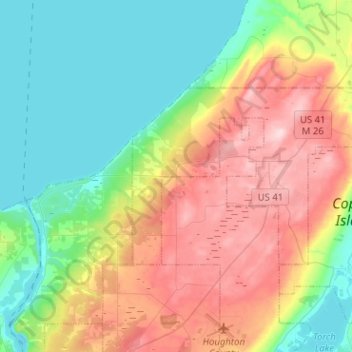
Name: Calumet Township topographic map, elevation, terrain.
Location: Calumet Township, Houghton County, Michigan, United States (47.19931 -88.55260 47.28610 -88.29899)
Average elevation: 856 ft
Minimum elevation: 581 ft
Maximum elevation: 1,309 ft
Houghton County trails, hiking, mountain biking, running and outdoor activities
Other topographic maps
Click on a map to view its topography, its elevation and its terrain.
Twin Lakes State Park
United States > Michigan > Houghton County > Toivola > Lake Roland
Average elevation: 1,184 ft