
Sopchoppy topographic map
Interactive map
Click on the map to display elevation.
About this map
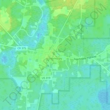
Name: Sopchoppy topographic map, elevation, terrain.
Location: Sopchoppy, Wakulla County, Florida, United States (30.04721 -84.50350 30.07455 -84.46773)
Average elevation: 30 ft
Minimum elevation: 7 ft
Maximum elevation: 56 ft
Wakulla County trails, hiking, mountain biking, running and outdoor activities
Other topographic maps
Click on a map to view its topography, its elevation and its terrain.