
Cumbaya topographic map
Click on the map to display elevation.
Cumbaya
At an elevation of 2200 m (7200 ft) above sea level, Cumbayá is lower than Quito and its climate is about 2 to 5 degrees Celsius warmer. Weather is semi tropical year-round, with a short rainy season.
About this map
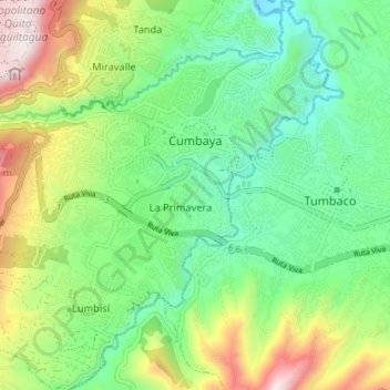
Name: Cumbaya topographic map, elevation, terrain.
Location: Cumbaya, Quito Canton, Pichincha, Ecuador (-0.24711 -78.47307 -0.17534 -78.40226)
Average elevation: 8,018 ft
Minimum elevation: 7,103 ft
Maximum elevation: 9,810 ft
Other topographic maps
Click on a map to view its topography, its elevation and its terrain.
Quito
Quito (Spanish pronunciation: [ˈkito] (listen); Quechua: Kitu), formally San Francisco de Quito, is the capital and most populous city of Ecuador, with an estimated population of 2.8 million in its urban area. It is also the capital of the province of Pichincha. Quito is located in a valley on the eastern…
Average elevation: 9,613 ft
Quito
Quito's elevation of 2,850 m (9,350 ft) makes it either the highest or the second highest capital city in the world. This varied standing is because Bolivia is a country with multiple capitals; if La Paz is considered the Bolivian national capital, it tops the list of highest capitals, but if Sucre is…
Average elevation: 9,613 ft
Quito
Quito's elevation of 2,850 meters (9,350 ft) makes it either the highest or the second-highest national capital city in the world. This varied standing is because Bolivia is a country with multiple capitals; if La Paz is considered the Bolivian national capital, it tops the list of highest capitals, but if…
Average elevation: 9,613 ft
Quito
Quito (Spanish pronunciation: [ˈkito] ; Quechua: Kitu), officially San Francisco de Quito, is the capital of Ecuador, with an estimated population of 2.8 million in its metropolitan area. It is also the capital of the province of Pichincha. Quito is located in a valley on the eastern slopes of Pichincha, an…
Average elevation: 9,613 ft
Quito
Quito's elevation of 2,850 m (9,350 ft) makes it either the highest or the second highest capital city in the world. This varied standing is because Bolivia is a country with multiple capitals; if La Paz is considered the Bolivian national capital, it tops the list of highest capitals, but if Sucre is…
Average elevation: 9,613 ft
Quito
Quito's elevation of 2,850 m (9,350 ft) makes it either the highest or the second highest capital city in the world. This varied standing is because Bolivia is a country with multiple capitals; if La Paz is considered the Bolivian national capital, it tops the list of highest capitals, but if Sucre is…
Average elevation: 9,613 ft