
Gia Lai Province topographic map
Interactive map
Click on the map to display elevation.
Gia Lai Province
Gia Lai is a mountainous province located in the northern Central Highlands at an average altitude of 700 - 800 m above sea level with an area of Convert 15510.13 km2, an average population of 1,590,980 people (2022). Gia Lai borders Kon Tum Province to the north, Dak Lak Province to the south, Cambodia to the west, and Quang Ngai, Binh Dinh, and Phu Yen Provinces to the east. The province has 17 administrative units including Pleiku City, 2 towns of An Khe, Ayun Pa, and 14 districts including Chu Pah, Chu Prong, Dak Doa, Chu Se, Chu Puh, Phu Thien, Mang Yang, Krong Pa, Kong Chro, Kbang, Ia Pa, Ia Grai, Duc Co, Dak Po. Pleiku City is the economic, political, cultural, and social center of the province.
About this map
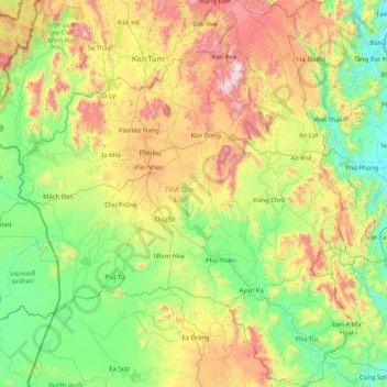
Name: Gia Lai Province topographic map, elevation, terrain.
Location: Gia Lai Province, Vietnam (12.99617 107.45082 14.60316 108.87332)
Average elevation: 1,539 ft
Minimum elevation: 16 ft
Maximum elevation: 5,751 ft
Other topographic maps
Click on a map to view its topography, its elevation and its terrain.
Ho Chi Minh City
Ho Chi Minh City is located in the south-eastern region of Vietnam, 1,760 km (1,090 mi) south of Hanoi. The average elevation is 5 m (16 ft) above sea level for the city center and 16 m (52 ft) for the suburb areas. It borders Tây Ninh Province and Bình Dương Province to the north, Đồng Nai Province and…
Average elevation: 20 ft
Yersin Park
Vietnam > Lâm Đồng Province > Phường Xuân Hương - Đà Lạt > Da Lat
Average elevation: 4,862 ft
Fansipan Mountain Peak
Vietnam > Lai Chau province > Xã Mường Khoa
Fansipan is the tallest mountain in the Hoang Lien Son range, situated on the border of Lào Cai and Lai Châu provinces, with its peak located on the Lào Cai side. The mountain is part of Hoàng Liên National Park. It has a topographic prominence of 1,617 metres (5,305 ft), ranking sixth in Vietnam.
Average elevation: 8,583 ft
Ba Den Mountain
Vietnam > Tay Ninh province > Phường Bình Minh
In early December 1974 heavy combat in Tây Ninh began, with People's Army of Vietnam (PAVN) rockets falling on the province capital and on adjacent military installations. The 80-man 3rd Company, 314th Regional Force Battalion guarding the radio relay station on the summit of Nui Ba Den began receiving…
Average elevation: 1,447 ft
Công Viên Trường Đại Học Phú Yên
Vietnam > Đắk Lắk province > Phường Tuy Hòa > Tuy Hòa
Average elevation: 20 ft
Quy Nhơn
Vietnam > Gia Lai Province > Phường Quy Nhơn
Quy Nhon has a varied topography, being extremely diversified with mountains and forests, hills, fields, salt marshes, plains, lagoons, lakes, rivers, shorelines, peninsulas and islands. Its coastline is 42 kilometres or 26 miles long with sandy beaches, abundant seafood resources and other natural products of…
Average elevation: 190 ft
Yersin Park
Vietnam > Lâm Đồng Province > Phường Xuân Hương - Đà Lạt > Da Lat
Average elevation: 4,862 ft
Hạ Long Bay
Vietnam > Quang Ninh Province > Ha Long
Due to a simultaneous combination of ideal factors such as thick, pale, grey, and strong limestone layers, which are formed by fine-grained materials; hot and moist climate and slow tectonic process as a whole; Hạ Long Bay has had a complete karst evolution for 20 million years. There are many types of karst…
Average elevation: 0 ft
Huế
The Perfume River (called Sông Hương or Hương Giang in Vietnamese) passes through the center of province. The province also accommodates the Tam Giang–Cau Hai lagoon, the largest lagoon in Southeast Asia, which is 68 kilometres (42 mi) long with a surface area of 220 square kilometres (85 sq mi). The…
Average elevation: 98 ft
Phú Lộc
Vietnam > Bà Rịa - Vũng Tàu Province > Xã Hòa Hiệp > Ho Chi Minh City
Average elevation: 256 ft