
Gia Lai Province topographic map
Interactive map
Click on the map to display elevation.
Gia Lai Province
Gia Lai is a mountainous province located in the northern Central Highlands at an average altitude of 700 - 800 m above sea level with an area of Convert 15510.13 km2, an average population of 1,590,980 people (2022). Gia Lai borders Kon Tum Province to the north, Dak Lak Province to the south, Cambodia to the west, and Quang Ngai, Binh Dinh, and Phu Yen Provinces to the east. The province has 17 administrative units including Pleiku City, 2 towns of An Khe, Ayun Pa, and 14 districts including Chu Pah, Chu Prong, Dak Doa, Chu Se, Chu Puh, Phu Thien, Mang Yang, Krong Pa, Kong Chro, Kbang, Ia Pa, Ia Grai, Duc Co, Dak Po. Pleiku City is the economic, political, cultural, and social center of the province.
About this map
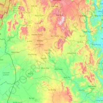
Name: Gia Lai Province topographic map, elevation, terrain.
Location: Gia Lai Province, Vietnam (12.99617 107.45082 14.60316 108.87332)
Average elevation: 1,539 ft
Minimum elevation: 16 ft
Maximum elevation: 5,751 ft
Other topographic maps
Click on a map to view its topography, its elevation and its terrain.
Lang Biang Mountain
Vietnam > Lâm Đồng Province > Phường Lang Biang - Đà Lạt
Average elevation: 5,860 ft
Ho Chi Minh City
Ho Chi Minh City is located in the south-eastern region of Vietnam, 1,760 km (1,090 mi) south of Hanoi. The average elevation is 5 m (16 ft) above sea level for the city center and 16 m (52 ft) for the suburb areas. It borders Tây Ninh Province and Bình Dương Province to the north, Đồng Nai Province and…
Average elevation: 20 ft
Phú Lộc
Vietnam > Bà Rịa - Vũng Tàu Province > Xã Hòa Hiệp > Ho Chi Minh City
Average elevation: 256 ft
Mỹ Thuận
Vietnam > Bà Rịa - Vũng Tàu Province > Long Dat District > Phuoc Hai Township
Average elevation: 33 ft
Quảng trường Thành phố Phan Rang-Tháp Chàm
Vietnam > Ninh Thuan province > Phan Rang – Tháp Chàm
Average elevation: 16 ft
Bắc Hưng Hải River
Vietnam > Hung Yen Province > Văn Giang District > Hà Nội > Xã Bát Tràng
Average elevation: 30 ft
Bản Nậm Cung
Vietnam > Lai Chau province > Phong Thổ District > Mường So Commune
Average elevation: 1,604 ft
Thi Vai River
Vietnam > Bà Rịa - Vũng Tàu Province > Long Thành District > Phú Mỹ
Average elevation: 33 ft