
Bloomfield topographic map
Interactive map
Click on the map to display elevation.
About this map
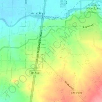
Name: Bloomfield topographic map, elevation, terrain.
Location: Bloomfield, San Juan County, New Mexico, United States (36.68963 -107.98470 36.69149 -107.98357)
Average elevation: 5,535 ft
Minimum elevation: 5,404 ft
Maximum elevation: 5,719 ft
San Juan County trails, hiking, mountain biking, running and outdoor activities
Other topographic maps
Click on a map to view its topography, its elevation and its terrain.
Navajo Lake State Park
United States > New Mexico > San Juan County > Navajo Dam
Average elevation: 6,450 ft
Aztec
United States > New Mexico > San Juan County
Yet another area managed by the BLM, this area was formed about the same time as the Bisti and Ah-Shi-Sle-Pah. This region offers a uniquely different scale of landscape. Hoodoo in this region are massive and the terrain much greater in elevation differences, thereby exposing a greater geological time frame…
Average elevation: 5,915 ft
Aztec
United States > New Mexico > San Juan County > Aztec > Aztec
Yet another area managed by the BLM, this area was formed about the same time as the Bisti and Ah-Shi-Sle-Pah. This region offers a uniquely different scale of landscape. Hoodoo in this region are massive and the terrain much greater in elevation differences, thereby exposing a greater geological time frame…
Average elevation: 5,797 ft