
Black Butte topographic map
Interactive map
Click on the map to display elevation.
Black Butte
According to the U.S. National Geodetic Survey and scientists from the United States Geological Survey, Black Butte has an elevation of 6,436 feet (1,962 m); the Geographic Names Information System database lists its elevation as 6,430 feet (1,960 m), while Oregon Geographic Names lists its elevation at 6,415 feet (1,955 m). The butte has proximal and draping reliefs of 2,490 feet (760 m) and 3,150 feet (960 m), which are the "difference between summit elevation and that of highest exposure of older rocks overlain by the edifice" and the "difference between summit elevation and that of lowest distal lavas of the edifice (not including distal pyroclastic or debris flows)," respectively. According to E. M. Taylor, Black Butte has a diameter of 4 miles (6.4 km).
About this map
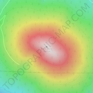
Name: Black Butte topographic map, elevation, terrain.
Location: Black Butte, Jefferson County, Oregon, United States (44.40003 -121.63651 44.40013 -121.63641)
Average elevation: 4,967 ft
Minimum elevation: 3,615 ft
Maximum elevation: 6,404 ft
Jefferson County trails, hiking, mountain biking, running and outdoor activities
Other topographic maps
Click on a map to view its topography, its elevation and its terrain.
Suttle Lake
United States > Oregon > Jefferson County
Suttle Lake is located near the crest of the Cascade Mountains in western Jefferson County, Oregon. Its elevation is 3,438 feet (1,048 m) above sea level. The lake is surrounded by the Deschutes National Forest. The lake is 13 miles (21 km) west of Sisters, Oregon and 90 miles (140 km) east of Salem, in the…
Average elevation: 3,671 ft
Peter Skene Ogden State Scenic Viewport
United States > Oregon > Jefferson County
Average elevation: 2,753 ft