
South Kalimantan topographic map
Interactive map
Click on the map to display elevation.
About this map
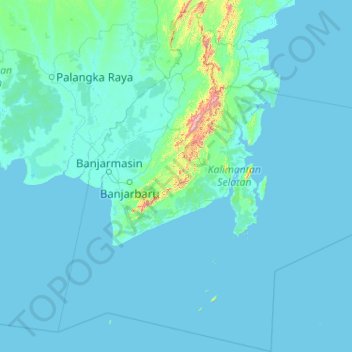
Name: South Kalimantan topographic map, elevation, terrain.
Location: South Kalimantan, Kalimantan, Indonesia (-5.41389 113.99113 -1.31258 117.90095)
Average elevation: 98 ft
Minimum elevation: -3 ft
Maximum elevation: 5,463 ft
Other topographic maps
Click on a map to view its topography, its elevation and its terrain.
Sepanjang Beach
Indonesia > Special Region of Yogyakarta > Gunungkidul Regency > Kemadang
Average elevation: 49 ft
Kolam Retensi Cieunteung
Indonesia > West Java > Kabupaten Bandung > Baleendah > Citeureup
Average elevation: 2,175 ft
Ijo Temple
Indonesia > Special Region of Yogyakarta > Sleman Regency > Sambirejo
The temple compound is located in Groyokan hamlet, Sambirejo village, Kecamatan Prambanan, Sleman Regency, Yogyakarta. The temple's name derived from its location, the Gumuk Ijo hill. The temple compound stood on western slope of the hill, in a quiet region east of Yogyakarta, around 4 kilometers southeast…
Average elevation: 764 ft
Mount Salak
Mount Salak is popular for many mountain climbing clubs, especially Route II, because of the difficulty involved in reaching the peak. Climbers bring water with them, especially through Post I at Kawah Ratu Route. A water source, supplied by rain, exists at an altitude of 2,211 m (7,254 ft) on this route.
Average elevation: 5,807 ft
Ngamprah
Indonesia > West Java > West Bandung
Ngamprah has an elevation moderated tropical rainforest climate (Af) with moderate rainfall from June to September and heavy rainfall from October to May.
Average elevation: 2,635 ft