
Saratov Oblast topographic map
Interactive map
Click on the map to display elevation.
About this map
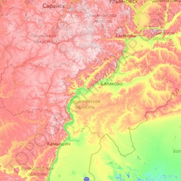
Name: Saratov Oblast topographic map, elevation, terrain.
Location: Saratov Oblast, Volga Federal District, Russia (49.09206 44.30320 54.21206 49.42320)
Average elevation: 404 ft
Minimum elevation: -66 ft
Maximum elevation: 1,207 ft
Other topographic maps
Click on a map to view its topography, its elevation and its terrain.
городское поселение Балаково
Russia > Saratov Oblast > городское поселение Балаково
Average elevation: 98 ft