
Sydney topographic map
Interactive map
Click on the map to display elevation.
Sydney
Sydney is on the east bank of the Sydney River where it discharges into South Arm of Sydney Harbour. Elevation ranges from sea level to 66 m (217 ft) above sea level.
About this map
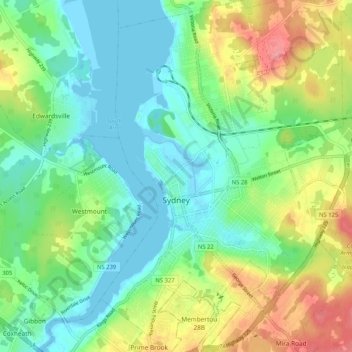
Name: Sydney topographic map, elevation, terrain.
Average elevation: 98 ft
Minimum elevation: -16 ft
Maximum elevation: 289 ft
Other topographic maps
Click on a map to view its topography, its elevation and its terrain.
Brown Islands
Canada > Nova Scotia > Cape Breton Regional Municipality > Main-à-Dieu
Average elevation: 0 ft
Meadows Road
Canada > Nova Scotia > Cape Breton Regional Municipality > Sydney Forks
Average elevation: 75 ft
Victoria Bridge
Canada > Nova Scotia > Cape Breton Regional Municipality > Upper Grand Mira
Average elevation: 56 ft
Centreville
Canada > Nova Scotia > Cape Breton Regional Municipality > Sydney Mines
Average elevation: 39 ft
Cranberry Lake
Canada > Nova Scotia > Cape Breton Regional Municipality > Enon
Average elevation: 338 ft
Salmon River Road
Canada > Nova Scotia > Cape Breton Regional Municipality > Grand Mira North
Average elevation: 59 ft