
Haibei topographic map
Interactive map
Click on the map to display elevation.
About this map
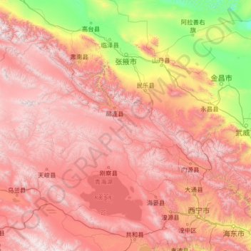
Name: Haibei topographic map, elevation, terrain.
Location: Haibei, Qinghai, 812300, China (36.74011 98.09266 39.09037 102.63975)
Average elevation: 9,728 ft
Minimum elevation: 4,006 ft
Maximum elevation: 17,244 ft
Other topographic maps
Click on a map to view its topography, its elevation and its terrain.
Golog Tibetan Autonomous Prefecture
China > Qinghai > Gadê County
The lay of the land of the prefecture is largely determined by the Amne Machin mountain range (max elevation 6,282 m), which runs in the general northwest- to-southeast direction across the entire prefecture, and beyond. The existence of the ridge results in one of the great bends of the Yellow River, which…
Average elevation: 14,239 ft
Tanggula Mountains
China > Qinghai > Yanshiping
The elevations of the main ridge average more than 5,000 m (16,404 ft). The Yangtze River originates in this mountain range; Geladandong, 6,621 metres or 21,722 feet high, located in Tanggula Town, is the tallest peak in the range.
Average elevation: 19,396 ft
Golog Tibetan Autonomous Prefecture
China > Qinghai > Maqên County > Golog Tibetan Autonomous Prefecture
The lay of the land of the prefecture is largely determined by the Amne Machin mountain range (max elevation 6,282 m), which runs in the general northwest- to-southeast direction across the entire prefecture, and beyond. The existence of the ridge results in one of the great bends of the Yellow River, which…
Average elevation: 13,609 ft