
Buenaventura topographic map
Interactive map
Click on the map to display elevation.
About this map
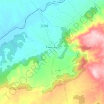
Name: Buenaventura topographic map, elevation, terrain.
Location: Buenaventura, Toledo, Castile-La Mancha, 45634, Spain (40.14069 -4.92468 40.20519 -4.82349)
Average elevation: 1,696 ft
Minimum elevation: 1,263 ft
Maximum elevation: 2,559 ft
Other topographic maps
Click on a map to view its topography, its elevation and its terrain.
Arenas
Spain > Castile-La Mancha > La Mancha > Alcázar de San Juan > Alameda de Cervera
Average elevation: 2,103 ft
Alto Llano
Spain > Castile-La Mancha > Mancha Alta de Toledo > Quintanar de la Orden
Average elevation: 2,290 ft